Clean, easing swell ahead of large onshore surf next week
Western Australia Surf Forecast by Craig Brokensha (issued Monday 18th May)
Best Days: Tomorrow, Wednesday, Thursday in the South West and early Friday
Recap
Saturday was expected to see a mix of new peaking W/SW groundswell and then afternoon increase in new SW groundswell but it looks like I got the timing a little wrong as the surf was large and maxing from dawn.
Large and clean 8ft+ waves were seen across the South West, 2-3ft in Mandurah, smaller and only to 2ft or so across Perth.
Our secondary pulse of large swell for yesterday came in as forecast with large surf continuing with clean conditions through the morning.
Today we've got less favourable and choppy conditions across the South West with a reinforcing SW groundswell maintaining 8ft+ sets on the exposed reefs, better in protected locations. Mandurah was a clean 3ft, with Perth 2ft and a bit bumpy and now 3ft sets showing.
This week and weekend (May 19 - 24)
This afternoon's reinforcing SW groundswell was generated by a strong trailing cold front pushing up and towards the state over the weekend, on the back of all the activity seen late last week. This swell will ease through tomorrow and conditions will improve across all locations as winds swing around to the E-E/SE with easing sets from 6-8ft in the South West, 2-3ft across Mandurah and 2ft in Perth.
Wednesday will be smaller again and conditions clean with a light E/SE offshore, S/SE into the afternoon.
As touched on in Friday's outlook there's nothing significant on the cards into the end of the week, with Perth and Mandurah expected to become tiny. The South West magnets should offer fun waves though with background energy to 3-4ft or so Thursday, becoming a bit smaller Friday and bottoming out Saturday.
 Winds look favourable though with an E/NE offshore Thursday, variable into the afternoon and then E/NE tending N/NE on Friday ahead of unfavourable and strong N/NE tending N/NW winds Saturday.
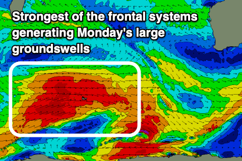
As also touched on in Friday's notes, we should see some better groundswell filling in from Sunday and more so early next week owing to a strong frontal progression forming west of the Heard Island region today.
An initial broad front will project strong to gale-force W/SW winds slowly towards us in our medium-range swell window over the coming days, followed by a better and stronger fetch of W/SW gales through the end of the week.
This secondary push will unfortunately continue east-northeast and push into us Sunday bringing an onshore change which looks to persist into Monday as a secondary mid-latitude front pushes into us.
What we'll see is the initial mid-period swell from the first front building later Saturday and peaking Sunday ahead of the large groundswell into Monday but mixed in with windswell from the fronts pushing across us.
Strong W/SW-SW winds on Monday will meet the swell which looks to come in around 8ft+ in the South West, 3-4ft in Mandurah and Perth. There may be a temporary reprieve in the onshore winds Tuesday in between another strong mid-latitude front pushing up and towards us. This unfortunately looks to be the start of sustained progression up and into us under the influence of a strong node of the Long Wave Trough. More on this Wednesday though.

