More large surf inbound
Western Australia Surf Forecast by Craig Brokensha (issued Monday 20th April)
Best Days: Perth and Mandurah Thursday morning, Friday morning, Perth and Mandurah Saturday morning, Sunday morning
Recap
The surf dropped further into Saturday with tiny waves in Mandurah and Perth for the keen, best in the South West to 3-4ft, with poor, onshore and building surf yesterday.
Today our first large and onshore swell has filled in across Margs and Mandurah, cleaner across Perth early.
This week and weekend (Apr 21 - 26)
The secondary front in the current progression we're seeing hitting the state under the effects of the Long Wave Trough is moving through now. This will generate a larger W/SW groundswell for tomorrow to 8-10ft across the South West, 3-4ft in Mandurah and 3ft across Perth but with strengthening W/NW winds across all locations, lighter NW early across Perth.
 We'll see the swell tail off in between fronts on Wednesday but winds will remain poor and out of the W/NW, with Thursday expected to show the first signs of lighter and more variable winds across Perth and Mandurah.
This will be along with our third large W/SW groundswell, produced by an elongated mid-latitude front that's currently just north-east of the Heard Island region.
The front will projected towards us bringing the onshore winds on Wednesday, but size wise Thursday, the South West should kick back to 8ft to occasionally 10ft, 3ft to occasionally 4ft in Mandurah and 3ft on the sets across Perth.
We'll see the swell ease through Friday as winds become lighter across all regions, light offshore out of the SE in Perth and Mandurah and more variable onshore across the South West. It won't be great around Margs but workable.
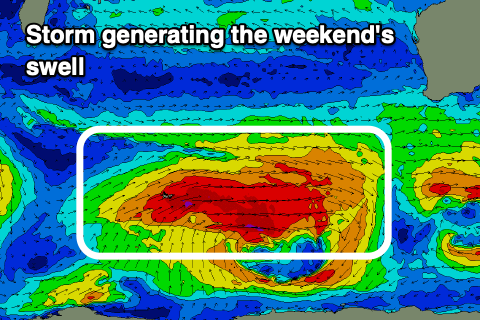
As talked about last update, the largest SW groundswell is likely to impact the state on the weekend, with a broad and significant polar low forecast to form around the Heard Island region mid-week. A fetch of severe-gale W/SW winds will span out across our south-western swell window, generating a large, long-period SW groundswell that should fill in Saturday and peak through the afternoon.
 Sets to 10ft+ are due across the South West, 3ft+ in Mandurah and 2-3ft across Perth. Winds will linger onshore across the South West unfortunately with cleaner conditions to the north, hopefully better Sunday morning with lighter S/SE breezes across the South West as the swell eases. We'll confirm this on Wednesday though.
After a couple of days breather, it looks like we'll see more activity into next week and beyond across the state, but check back here on Wednesday for more on this.

