Not the best end to the week, clean from the weekend
Western Australia Surf Forecast by Craig Brokensha (issued Wednesday 1st April)
Best Days: Friday morning keen surfers in the South West, desperate surfers late morning each day on the weekend, Tuesday from late morning, similar Wednesday
Recap
Monday afternoon's large pulse of S/SW groundswell eased into yesterday as conditions improved across the South West, not great in the morning but better as the day progressed. Mandurah was a good and clean 2-3ft, 2ft in Perth.
Today conditions are pumping in the South West with a reinforcing S/SW swell and clean 5-6ft waves, 2-3ft in Mandurah though tiny across Perth.

This week and weekend (Apr 2 - 5)
Today's reinforcing swell will ease back through tomorrow and an approaching cold front come mid-latitude low will unfortunately bring onshore S/SW-SW winds across the South West, more favourable and S'ly early to the north. Try protected spots around Mandurah for a small 1-2ft wave.
This front now looks to move quicker through our swell window, with no major size due from the short-range swell it'll generate on Friday, with tiny waves in Perth and Mandurah and 4-5ft sets in the South West.
Winds are looking better for Friday morning though as the front moves off quicker to the east, resulting in a SE'ly across the South West ahead of afternoon sea breezes.
 As touched on in Monday's notes, offshore E'ly winds are expected on the weekend, though strong in the mornings with no major swell. Background pulses of mid-period and long-period energy should keep 3-4ft sets hitting the South West Saturday and Sunday, best from later morning on the former ahead of sea breezes, similar on the latter.
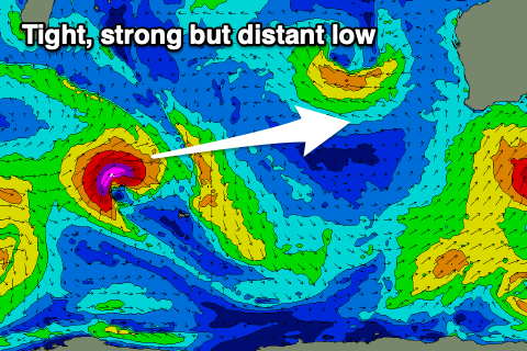
The small pulse of long-period W/SW groundswell for early next week is still on track with a tight and short-lived low due to form south-east of Madagascar tomorrow. A fetch of gale to severe-gale W/SW winds will be projected east through our more western swell window, weakening while tracking south-east Friday.
A small to moderate sized and short-lived burst of long-period swell is due, arriving overnight Monday and building Tuesday, reaching 2ft across Perth and Mandurah on the sets (inconsistent) with 4-6ft sets across the South West.
Winds look favourable though gusty in the mornings Monday and Tuesday out of the E/NE, variable N/NE into the afternoon as the swell peaks. Wednesday looks to play out similar as the swell eases.
Longer term a closer and broader low is forecast to form in the central Indian Ocean, generating a better swell later week, but we'll have a closer look at this on Friday.


Comments
It is looking sounding and feeling ideal. Thank you.