Fun waves tomorrow, tricky thereafter with larger swells from the weekend
Western Australia Surf Forecast by Craig Brokensha (issued Friday 4th October)
Best Days: Tuesday morning, Thursday morning keen surfers in the South West, protected spots Saturday morning, Tuesday next week
Recap
Friday's funky mix of NW and SW swells with offshore winds backed off into Saturday with fresh S'ly winds and generally average conditions across all locations besides the odd protected spot. Perth was cleaner but small.
Sunday was a bit cleaner across the northern end of the Cape in the South West with the swell back to the 4ft range, clean to the north but tiny.
Today conditions were cleaner again across most locations with the swell hanging in at 3-5ft in the South West, 1-2ft in Perth and Mandurah, and a new mid-period SW swell is due into this afternoon but with sea breezes.
This week and weekend (Oct 8 - 13)
The new mid-period SW swell expected to build this afternoon should peak early tomorrow with sets around 6ft around the South West, 2ft+ in Mandurah and 1-2ft in Perth with a moderate to fresh E/NE offshore, variable ahead of sea breezes. The swell will ease through the day.
We'll see a trough move in on Wednesday bringing less favourable and strong S/SE winds as the swell continues to ease.
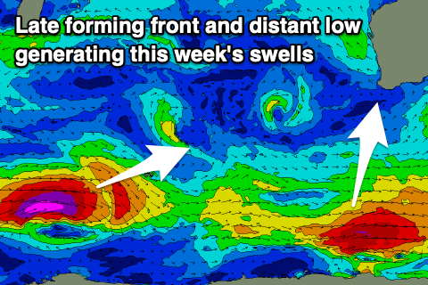
Thursday will be smaller again, though the South West magnets might see a mid-period S/SW swell, generated by a strengthening polar front really late in our swell window, south of us today.
 Sets to only 3-4ft are expected across south swell magnets, tiny in Perth and Mandurah along with a less than favourable SE (possibly E/SE breeze).
As touched on last update, a new long-period SW groundswell is expected late week, though as also discussed, winds will be less than ideal.
The source of the swell is a small and tight polar low that's developed south-southeast of South Africa, with a severe-gale to storm-force fetch of W/SW winds being projected east through our far-medium range swell window.
The low will weaken around the Heard Island region tomorrow afternoon, with the remnants pushing up and towards us later week, generating an additional W/SW windswell to the mix. We'll end up seeing a weaker trough from this front moving through on Friday evening, bringing a S'ly change and S/SE winds Saturday morning.
Friday morning will start slow, with the long-period energy arriving into the afternoon and more so later in the day before peaking Saturday to 6ft to occasionally 8ft in the South West, 2ft+ in Mandurah and 1-2ft in Perth.
We may see winds swing onshore as the swell eases Sunday, but we'll have to review this Wednesday.
Longer term a larger SW groundswell is on the cards for early next week, generated by a strong polar low forming around the Heard Island region and projecting east-northeast while producing a fetch of severe-gale to storm-force W/SW winds.
A peak in swell is likely Tuesday with favourable winds, but check back here Wednesday for more on this.

