Large swell this week as gale-force winds move in
Western Australia Surf Forecast by Craig Brokensha (issued Monday 30th September)
Best Days: Tomorrow morning keen surfers, Wednesday morning, Thursday, Saturday protected spots keen surfers, Monday and Tuesday week
Recap
Friday's pumping swell eased back rapidly into Saturday, with fun options in protected spots.
Our new long-period SW groundswell for Sunday came in under expectations with the South West increasing to an infrequent 6ft+ sets, only 1-2ft to the north but with great conditions. This is a little puzzling as satellite observations of the swell generating fetch were good on Friday.
This swell has dropped back into today with early light winds which are now onshore.
This week and weekend (Oct 1 - 6)
Tomorrow we've got a lift in new mid-period W/SW swell through the afternoon, easing Wednesday.
This has been generated by a broad and prolonged but relatively weak frontal system that developed south-east of South Africa and pushed slowly east through the southern Indian Ocean, then slipping east-southeast on approach to us.
 A moderate to large W/SW swell is due, building to 6ft+ across the South West into the afternoon, 2-3ft in Mandurah and 2ft+ in Perth, easing back from a similar size Wednesday morning.
Winds will be generally S/SE tomorrow morning (more SE around Mandurah) but the surf only due to kick into the afternoon when sea breezes kick in.
Wednesday looks better with variable winds likely at dawn in the South West (E/NE further north) and then shifting NW into the afternoon.
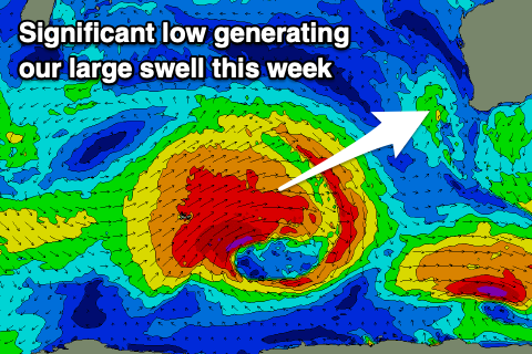
The larger, long-period SW groundswell due into the end of the week is still on track, with a very broad and strong low now sitting just east of Heard Island.
A fetch of severe-gale to storm-force W/SW winds have been aimed towards us, with the low now moving slowly east, with it due to weaken tomorrow evening south-west of us.
The large swell is expected to arrive before dawn Thursday and build rapidly through the day, reaching 10-12ft across the South West, 3-4ft in Mandurah and 3ft on the sets in Perth by late afternoon, easing Friday.
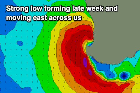
 As touched on last week though, a deepening trough come mid-latitude low will create tricky winds, likely E/NE tending SE across the South West and NE tending W/NW across Perth and Mandurah as they feel the northern flank of the low.
Friday will then be poor as the low moves east, bringing gale-force S/SW winds to the South West, W/SW in direction further north and a large additional increase in stormy windswell.
The windswell will ease off through Saturday as winds improve, backing off but lingering from the S'th.
Longer term a mid-period SW swell is expected early next week with S/SE winds, cleaner and easing through the middle of the week, but we'll have a closer look at this Wednesday.

