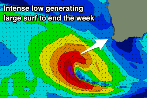
Large windy swell to end the week, cleaner from the weekend
Western Australia Surf Forecast by Craig Brokensha (issued Wednesday 2nd January)
Best Days: Perth and Mandurah Friday morning, the South West and Mandurah Sunday morning, Monday morning and Tuesday morning
Recap
Clean building surf through yesterday morning across the South West, large into the afternoon but bumpy with sea breezes. Mandurah and Perth were tiny but showed more size though average conditions after lunch.
The swell was still a good size across Perth and Mandurah this morning but average with freshening onshore winds, bumpy though workable across the South West.
Today’s Forecaster Notes are brought to you by Rip Curl
This week and weekend (Jan 3 - 6)
Currently a strong mid-latitude low has formed west-southwest of the state and we're seeing a fetch of gale-force W/SW winds being projected towards us, with the backside of the low moving more into our swell window this evening and becoming stronger.
 The low is forecast to pass under our South Coast tomorrow morning, moving out of our swell window into the afternoon.
We should see a large increase in W/SW tending SW swell that now looks to reach an easy 8ft, if not bigger through the afternoon across the South West, 3ft+ in Mandurah and 2-3ft in Perth.
Winds will be an issue and onshore and strong from the SW most of the day, while Friday still looks onshore with W/SW winds across the South West, cleaner in Mandurah and Perth with a SE offshore. Size wise Margs should ease from 6-8ft, 3ft in Mandurah and 2ft+ in Perth.
Saturday will be smaller again though cleaner across the South West with a S/SE wind (E/SE further north).
A reinforcing mid-period SW swell is due to fill in Saturday afternoon and peak Sunday morning, produced by a secondary weaker front pushing in behind the low.
Margs should kick to 4-5ft and ease from a similar size Sunday morning with 1-2ft sets around Mandurah and 1-1.5ft waves in Perth.
Conditions will be great Sunday though with an E/SE offshore across all locations, strong S/SE into the afternoon across the South West.
Our new long-period S/SW groundswell for early next week is still on track, with a strong polar low due to to form late in our swell window.
A polar fetch of W/SW gales will move strengthen to our south, with a moderate S/SW groundswell due to build Monday and peak into the afternoon.
Size wise magnets in the South West look to build to 5-6ft, with small 1-2ft waves in Mandurah again, tiny to the north. Winds Monday look good most of the day, offshore out of the E/SE tending variable early afternoon ahead of sea breezes, and then SE Tuesday as the swell drops from a slightly smaller size.
Longer term there's nothing significant due through the rest of next week, but more on this Friday.

