Large onshore weekend, much better next week with a large reinforcing swell

Western Australia Surf Forecast by Craig Brokensha (issued Friday 27th October)
Best Days: Protected spots Sunday afternoon, every morning next week, best Monday and Wednesday
Recap
Poor conditions yesterday and today with building levels of windswell yesterday, with a bit more grunt today, but no real decent surfing options.
This weekend and next week (Oct 28 – Nov 3)
Today's mid-period swell was generated by an initial cold front pushing up from the Heard Island region, and across us yesterday.
We should see a secondary similar sized pulse of SW swell through tomorrow, produced by a secondary polar front pushing up from a more south-west angle, with this system currently passing under our South Coast.
We should see Margs offering 6-8ft sets on the exposed reefs tomorrow morning, with a touch more power again, while Perth looks to drop back to the 2ft+ range, with 2-3ft sets around Mandurah.
Winds will remain poor and straight onshore though as a deepening low approaches from the south-west, resulting in strong W'ly winds all day.
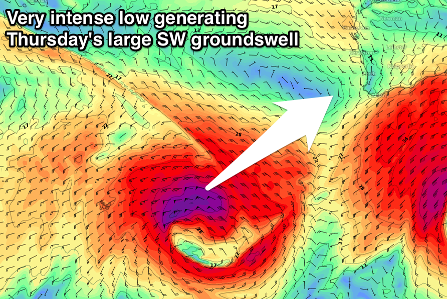 This secondary low will be the strongest of the bunch, with a broadening fetch of severe-gale W/SW winds moving through our south-western swell window, with core wind speeds to the storm-force range late in our southern swell window tomorrow evening before the system moves off to the east.
A larger longer-period SW groundswell should be seen from this low, mixed in with a fair bit of mid-period energy.
With the storm-force winds only forming late in our swell window, I've downgraded the size expectations with Margs expected to peak Sunday morning to the 12ft+ range across exposed breaks, with 3-4ft sets in Mandurah and 3ft sets up in Perth.
Winds will continue to be a problem as we feel the backside of the low, with a fresh to strong but easing SW tending S/SW breeze due (opening up options in protected spots).
Monday is still the day to surf as a high moves in, swinging winds light offshore across all locations as the SW swell eases back steadily from 8ft or so on the sets across Margs, 3ft in Mandurah and 2ft+ around Perth.
Winds will revert back to the SE on Tuesday morning as a weak trough moves in and the SW swell will continue to ease.
As touched on last update, a secondary strong and deep low is expected to produce a good new long-period SW groundswell that may be seen on dark Tuesday, peaking Wednesday morning.
A great fetch of severe-gale to storm-force W'ly winds will be generated in our south-western swell window, with large surf to 8-10ft expected on Wednesday morning across the South West reefs, 3ft in Mandurah and 2ft to occasionally 3ft around Perth. Winds look favourable and from the SE, but we'll have to confirm this Monday. Beyond this there's nothing major on the cards, so make the most of next week. Have a great weekend!
Comments
Hi Craig, is there any update on the outlook for the Margs coast for Wednesday? I hope the boss isn’t reading this as i’m thinking of calling in sick;) Thanks.
RIP forecasting?
Reckon Craig is away on a well earned break. Funny how we miss free, detailed forcasts when they aren't delivered 3 times a week.
Always the old school way. Check a chart, take a punt and grab some mates for a road trip for a surf. A pie and choccy milk on the way there and a beer or 2 on the way home.
Surfed 2 foot onshore beachies but had a great day.
Perspective!