Small swell for tomorrow, large building onshore surf late week
Western Australia Surf Forecast by Craig Brokensha (issued Monday 23rd October)
Best Days: Tuesday morning across the South West, early next week when the storm activity subsides
Recap
Small windy waves at swell magnets across the South West Saturday as winds remained offshore all day, tiny further north.
Sunday was smaller again with weaker offshore winds favouring the swell magnets before sea breezes kicked in.
This morning the swell bottomed out along with onshore winds across most locations, but some small SW energy is just starting to build across the South West.
This week and weekend (Oct 24 – 29)
Later today's increase in SW groundswell, peaking through tomorrow, was generated by a small, tight and slow moving polar low through our swell window Friday and Saturday.
No major size is due off this system, but the South West should see 4-5ft sets across magnets tomorrow, with 1-1.5ft sets in Mandurah (1ft Perth), easing back quickly into Wednesday.
Winds should be favourable early tomorrow across all locations with a variable tending light offshore breeze, giving into sea breezes around Perth and Mandurah, with a W/NW breeze across the South West as a cold front approaches from the west.
 This front will leave onshore W/NW winds across Margs into Wednesday as the swell fades, with variable winds to the north early though with no swell.
This front will generate some mid-period W/SW swell for Thursday afternoon, though overpowered by a secondary stronger and broader mid-latitude frontal system moving in from the west.
This activity and further fronts Friday and into the weekend will be a result of a strengthening node of the Long Wave Trough moving in from the west mid-late week, spreading out across the southern half of the country into early next week.
With this we'll see front after front projecting up and across us, becoming stronger with each succession, owing to the strengthening nature of the LWT.
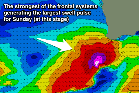
At this stage the strongest system looks to push through over the weekend and leading up to that we'll see building levels of onshore W/SW swell Thursday, larger Friday and reaching the XL size range through Sunday.
The models are still divergent regarding the timing and strength of each system but we should see Margs building to the 5-6ft range later Thursday with strong W/NW tending W/SW winds, further to an easy 8ft through Friday and then 10ft range later Saturday.
Perth and Mandurah look to build to 2ft+ with windswell later Thursday, more so to 3ft Friday afternoon with a stronger groundswell, holding Saturday, with possibly more size Sunday.
Onshore winds from the western quadrant will influence all locations through Friday and the weekend. Conditions should improve into early next week as the activity pushes further east, but we'll have to have a closer look at this on Wednesday.

