Great surf to end the week
Western Australia Surf Forecast by Craig Brokensha (issued Wednesday 18th October)
Best Days: All regions Thursday and Friday mornings, swell magnets in the South West Saturday and Sunday morning
Recap
Solid stormy amounts of W/NW swell across all locations yesterday but with no quality options. This morning the surf was smaller and still poor across all locations.
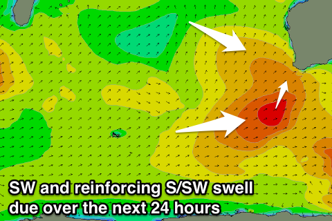
We should see a new SW groundswell building this afternoon, reaching 6-8ft later in the day across the South West, with Perth and Mandurah holding their size.
This week and weekend (Oct 19 - 22)
Later this afternoon's increase in SW groundswell will peak overnight and ease through tomorrow, slowed slightly by a secondary reinforcing S/SW groundswell arriving through the day.
 This swell is being generated by a fast moving mid-latitude front currently projecting up towards us through our southern swell window and will move on further east towards the Bight later this evening.
Slowly easing surf from the 6ft+ range is due across the South West (odd bigger bomb at swell magnets) and 2-3ft on Perth and Mandurah.
A ridge of high pressure moving in from the west is still expected to create great conditions with a straight E'ly breeze due to develop across all locations, giving into late afternoon sea breezes, while Friday will see the swell ease under fresh E/NE tending variable and then S/SE winds across the South West.
Saturday will see the swell easing further, back from 3ft to occasionally 4ft across the South West and 1ft+ further north under morning E/NE winds again, smaller Sunday and clean through the morning.
Next week onwards (Oct 23 onwards)
There's nothing too significant on the cards for next week with a relatively weak but intense polar low expected to generate a new SW groundswell for Monday and Tuesday. This swell wont offer any major size around Mandurah or Perth, while Margs should build to 3-4ft Monday afternoon, with better sets to 4-5ft Tuesday, easing Wednesday.
A weak trough moving in Monday looks to bring onshore winds to most locations lingering into Tuesday but possibly variable early. Wednesday looks similar but with more strength in the onshore winds around Margs, cleaner to the north but with no decent swell.
Longer term we're likely to see a series of cold fronts pushing into us later next week/weekend, but more on this Friday.

