Large messy surf Saturday, improving Sunday, best Monday
Western Australia Surf Forecast by Craig Brokensha (issued Wednesday 30th August)
Best Days: Protected spots Saturday, Perth and Mandurah Sunday morning, all locations Monday morning
Recap
As small as it gets across the West Oz coast yesterday with hardly any surfable swell, while today some new inconsistent W/SW groundswell has started to build, but winds were onshore in the South West. Perth and Mandurah saw a tiny increase in size to 1ft with variable winds.
This week and weekend (Aug 31 – Sep 3)
Today's inconsistent W/SW groundswell should reach 6ft on the sets across the South West and 1-1.5ft further north before starting to ease slowly through tomorrow.
Conditions will be poor across all locations as a weakening front pushes into us, bringing fresh W/NW tending W/SW winds. Some new swell is due from this front later in the day, peaking Friday morning to 5-6ft across the South West and 2ft in Perth and Mandurah.
 Winds will remain poor and onshore with a freshening W/SW tending stronger SW breeze as a strong cold front pushes up and into the state.
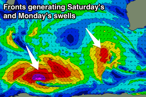
This front is linked to a larger SW groundswell due on Saturday morning, produced by its early incarnation.
This system is currently east of Heard Island, with a broad fetch of W/SW gales being projected up towards us through this evening and tomorrow, followed by a secondary intensification of SW gales up and into us Friday afternoon and evening.
Some mid-period swell is due to build late in the day Friday but a peak is expected Saturday with messy 10ft surf (3-4ft Perth and Mandurah) along with strong S/SW winds. Protected spots will fair best.
Sunday still looks onshore across the South West as noted in Monday's update with S/SW breeze, but Perth and Mandurah will see light E/SE offshores and easing 2-3ft sets.
Our large long-period S/SW groundswell due into Monday is still on track with a vigorous polar frontal progression due to form west of the Heard Island region this evening, generating a fetch of severe-gale to storm-force W/SW winds, before pushing up towards the Bight through the weekend.
A large long-period S/SW groundswell should result, peaking Monday to 8-10ft in the South West and 2-3ft around Perth and Mandurah along with light offshore E/NE winds.
After this swell there's nothing too major on the cards so it's worth planning around.

