No escape from the onshore conditions just yet
Western Australia Surf Forecast by Craig Brokensha (issued Monday 7th August)
Best Days: Keen surfers Thursday afternoon and early Friday
Recap
Large onshore waves across all locations Saturday, much better north of Margs into Sunday with lighter winds from the N/NE and fun 2-3ft sets.
Today the swell was smaller again with onshore winds continuing across the South West with lumpy and peaky 2ft sets to the north with lighter N/NE winds again.
This week and weekend (Aug 8 - 13)
In short, we've got another couple weeks of onshore winds in store, with the window of clearing weather identified last week not looking to eventuate.
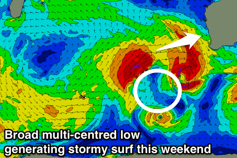
The AAO/SAM index is back to neutral, which indicates no real bias in the westerlies being closer or further away than normal but we'll continues to see mid-latitude systems firing up through the Indian ocean, with a very broad and intense multi-centred low due to generate back to back oversized stormy swells over the coming period.
Firstly, the frontal system responsible for today's onshore winds is generating a large W/SW groundswell which is due to fill in Wednesday. The front will also slam into the north of the state on Wednesday, moving across the South West through the late afternoon, generating some additional windswell in the mix.
Tomorrow will remain small with fresh N/NW tending W'ly winds as the change starts to move through.
Wednesday should reveal surf in the 6-8ft range across Margs with 2-3ft waves in Perth, kicking up a gear as the strong onshore SW change moves through (a touch weaker from the W/SW early).
 Thursday should see easing surf from a similar 6-8ft in the South West and 3ft around Perth with fresh SW tending W/NW winds. Lighter W/NW winds around Perth and Mandurah into the afternoon may provide a small window for keen surfers.
A better N/NE breeze is expected across Perth and Mandurah Friday morning but the swell will be weak, small and easing from 1-2ft. Margs will remain poor and onshore with N/NW winds and a weak swell.
From Friday we'll see a broad and vigorous low forming to our south-west, with multiple embedded fetches of gale to severe-gale W/SW winds being aimed towards us, followed by polar fronts slamming us with SW winds into early next week.
With this we're due to very large stormy surf developing through Saturday, persisting Sunday and Monday, with a temporary drop back Tuesday morning before the swell from the polar fronts slam into us.
All of this swell will be along with onshore winds from the western quadrant with no windows around Perth or Mandurah. We'll have another look at this Wednesday.


Comments
FML
Craig::
"From Friday we'll see a broad and vigorous low forming to our south-west, with multiple embedded fetches of gale to severe-gale W/SW winds being aimed towards us, followed by polar fronts slamming us with SW winds into early next week.
With this we're due to very large stormy surf developing through Saturday, persisting Sunday and Monday, with a temporary drop back Tuesday morning before the swell from the polar fronts slam into us."
You called it good weeks ago mate.
Wow, what did we do to piss off Huey this winter
Firewood runs in the rain is about as exciting as it gets at the moment
Time for a run up north