Slim window of lighter winds tomorrow morning
Western Australia Surf Forecast by Craig Brokensha (issued Wednesday 26th July)
Best Days: Perth and Mandurah Thursday morning, possibly later Sunday, protected spots Tuesday and Wednesday
Recap
A period of fun conditions across Perth and Mandurah yesterday morning with 2ft of swell before the NW'ly kicked in. Margs remain average and onshore.
This morning there was a bit more size on all coasts but conditions were poor again with fresh onshore winds and heavy rain squalls moving through.
The large long-period W/SW groundswell due into this afternoon is showing on the wave buoys across the coast but the size is hard to discern this morning under the local windswell and onshore winds.
This week and weekend (Jul 27 – 30)
This afternoon's long-period and inconsistent W/SW groundswell should reach 10ft to occasionally 12ft across exposed reefs in the South West, with 3ft sets to the north, easing back into tomorrow.
This will be mixed in with some more consistent and weaker mid-period energy, generated by a weak front currently pushing into us.
The South West should ease back from the 8ft range with 2-3ft waves to the north and a dawn N/NE'ly will create better, but still average conditions. Perth and Mandurah will be cleaner and the go to for a wave before a stronger N/NW breeze develops through the day.
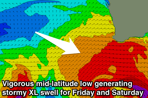
 Into Friday we'll see the first of a series of vigorous storms impacting the state over the coming period, with a deep mid-latitude front due to project a fetch of severe-gale W/SW winds towards us before forming into a broader mid-latitude low, projecting an additional fetch of severe-gale W/SW winds into us.
A mix of stormy W/SW groundswell and windswell will fill in Friday across all locations, reaching 12ft+ across the South West and 3-5ft in Perth and Mandurah along with strong to gale-force W'ly winds.
Saturday will continue to offer similar sized surf from the additional fetch as strong W/SW winds persist across the coast.
Another smaller but intense front will push into us Saturday evening, keeping Margs up in the 10-12ft range through the morning Sunday, with 3-4ft surf to the north along with fresh but easing SW tending W/NW winds. We may actually see variable winds across Perth mid-late afternoon, but we'll review this Friday.
Next week onwards (31 Jul onwards)
Into next week we're due to see two oversized long-period groundswells impacting the coast. The first is already starting to take shape as a vigorous polar low forms south-east of South Africa. A fetch of severe-gale W/SW winds will stall temporarily before tracking east-northeast towards us through the weekend, weakening and crossing the South West Monday afternoon.
We'll see onshore NW tending S/SW winds with this front, with the groundswell filling in through Tuesday afternoon and Wednesday.
Winds will be a little more favourable and from the S'th with sets reaching 8-10ft in the South West and 2-3ft around Perth and Mandurah.
A stronger and larger long-period W/SW groundswell is then due late week, produced by a very broad and intense polar low forming west of Heard Island, but we'll discuss this in more detail Friday.

