Large onshore waves to continue
Western Australia Surf Forecast by Craig Brokensha (issued Monday 24th July)
Best Days: Dawn Thursday mainly in Perth and Mandurah
Recap
A continuation of poor conditions across the southern half of the state over the weekend with large onshore waves Saturday, smaller and onshore Sunday.
Today the swell remained on the smaller size as onshore winds continued in the South West, while our window of clean conditions was seen around Perth and Mandurah with fun 2ft sets.
This week and weekend (Jul 25 – 30)
Our poor run of winds and large swell is still on track for the coming couple of weeks with a combination of a strong negative SAM/AAO event and stalling node of the Long Wave Trough in our region conspiring against us.
The negative SAM event will see the polar westerlies shifted more north towards us, and this will then be amplified by the presence of the Long Wave Trough.
Firstly a long-range and inconsistent W/SW groundswell due this afternoon should hold around 6ft+ across the South West and 2ft+ in Perth and Mandurah tomorrow with increasing W/NW tending NW winds.
Our larger long-period W/SW groundswell for Wednesday afternoon is still on track, generated by a vigorous storm firing up under South Africa later last week and over the weekend. The storm weakened west of Heard Island and with this, sets will be very inconsistent, but we should see Margs building to the 10ft to occasionally 12ft range into the afternoon, with 3ft sets in Perth and Mandurah. This will be contaminated by strengthening W/NW tending W/SW winds as a vigorous mid-latitude low pushes into us.
A mix of W/SW groundswell and W/SW windswell should then ease into Thursday with a period of light NE winds around Perth and early fresh N/NE breezes in the South West ahead of a stronger N/NW'ly through the late morning/afternoon linked to a vigorous mid-latitude storm approaching from the west.
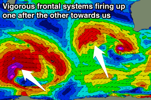
 This storm is forecast to project a fetch of severe-gale to storm-force W/SW tending winds through our swell window before moving across us Friday.
We'll see large stormy surf developing Friday as the storm moves across us, building to the 12-15ft range in the South West and 3-5ft in Perth with strong W'ly tending W/SW winds.
The swell and winds should ease off through Saturday but a fresh W/SW'ly will persist across all locations, smaller and W/NW tending NW into Sunday.
Another vigorous polar frontal system will fire up west of the Heard Island region, projecting a fetch of severe-gale W/SW winds up and towards us through Friday and the weekend.
With this another XL W/SW groundswell is due into early next week. Winds are the issue again with onshores likely, although there's a chance we may see more variable breezes in between fronts, but more on this Wednesday.
Longer term another XL swell is on the cards for late next week, but we'll have another look at this Wednesday.

