Large onshore swells still on for the weekend
Western Australia Surf Forecast by Craig Brokensha (issued Friday 30th June)
Best Days: Perth and Mandurah Sunday morning, protected spots around Margs Sunday, early Monday all locations
Recap
Wednesday's fun window of waves across the South West was very short-lived with stronger N/NE winds and a drop in swell creating poor conditions across all locations yesterday.
Today we've got similar poor conditions with the swell coming from the N/NW along with fresh to strong N'ly winds.
A W/SW change has since hit the South West and is making its way north-east towards Mandurah and Perth.
This weekend and next week (Jul 1 – 7)
Today's change is linked to a strong polar front that developed east of Heard Island, projecting a fetch of gale to severe-gale SW winds towards us.
The progression is looking a touch weaker than forecast on Wednesday along with the secondary sling-shot of S/SW gales, but we'll still see a large SW groundswell building tomorrow, with a reinforcing S/SW pulse for Sunday morning.
The South West should build to 10ft+ later tomorrow, easing back from a similar size Sunday morning, with 3ft sets developing around Mandurah and Perth, easing Sunday.
Conditions are still looking poor with a strong W/SW tending SW breeze tomorrow, lingering from the S/SW-S across the South West Sunday. Protected locations should offer OK waves for keen surfers.
Perth and Mandurah will see better S/SE-SE winds Sunday morning, creating good conditions.
Monday will be best across the South West with an early E/NE breeze and easing swell from 4-6ft. Perth and Mandurah should offer 1-2ft sets with that early offshore ahead of an change.
This change will be weak and in the form of a trough, shedding off the final stages of a weakening polar low in our southern swell window.
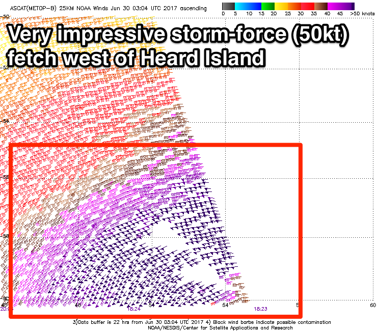
The low has currently formed west of Heard Island and a fetch of storm-force W'ly winds are being generated in our southern swell window.
 We'll see the low move slowly east today and tomorrow while continuing to generate severe-gale W/SW winds, resulting in the generation of a large long-period S/SW groundswell.
The swell should arrive through Tuesday, building to 6-8ft+ across the South West into the afternoon, with building 2ft+ sets in Perth and Mandurah late in the day.
Unfortunately the trough due through Monday will linger into Tuesday bringing light S'ly tending W/SW winds to the South West (more variable to the north).
This will then be follow by a stronger frontal system Wednesday, creating terrible conditions and also kicking up a large stormy mid-period SW swell.
Longer term an even stronger polar low is due to projected up towards us and through the Bight mid-late next week, generating a larger S/SW groundswell but with what looks to be S/SW winds. More on this Monday. Have a great weekend!

