Small surf this week, large windy swell for the weekend
Western Australia Surf Forecast by Craig Brokensha (issued Monday 26th June)
Best Days: Swell magnets in the South West Wednesday and early Thursday, protected spots later Saturday and Sunday around Margs, Sunday further north
Recap
Good fun waves across Margs magnets over the weekend with an easing S/SW swell while Perth and Mandurah were clean but best left to beginners with tiny peelers.
This morning the swell was still small to tiny across the state, with slightly bumpy conditions across the South West, leaving no decent options.
This week and weekend (June 27 – Jul 2)
There's been no real change to the coming days forecast with background swell energy due to ebb and pulse between 3-5ft across swell magnets in the South West with tiny 1ft waves further north.
This is due to a large high blocking our to our west, deflecting storms away from our main swell window.
Instead we have to rely on distant, inconsistent and small background swell energy over the coming week.
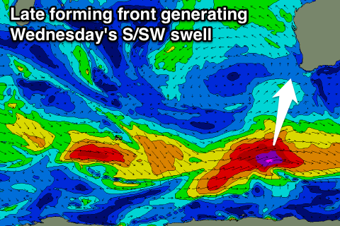
 On Wednesday a slightly more consistent S/SW swell (4-5ft south magnets) should be in the mix, generated by a developing cold front to our south today, late in our swell window.
Into Thursday afternoon and Friday a very inconsistent W/SW groundswell is due, generated late last week by a strong storm directly under South Africa.
This should produce 4-5ft sets at magnets, but there'll be waits of 10 minutes or so between them.
Conditions are looking average tomorrow with a S/SE breeze now due across Margs, better Wednesday and offshore from the E/NE, favouring those south magnets.
Thursday will see winds tend more NE through the morning, and then N/NW into the afternoon with an approaching front and then fresh NW tending SW winds Friday as the front pushes through.
This frontal progression is looking quite nice, with it forming south-west of us on Wednesday evening.
A fetch of gale to severe-gale SW winds will be projected north-east towards us through our southern swell window, producing a large S/SW groundswell for Saturday, with a secondary intensification Saturday morning, helping keep wave heights up Sunday.
We should see the South West building to 10-12ft Saturday afternoon, with 3ft sets in Perth and Mandurah, easing from a slightly smaller size Sunday.
Winds will unfortunately be onshore across the state Saturday with the passing front (W/SW tending SW), with lingering SW winds across the South West Sunday morning (E/SE further north).
Monday should be cleaner across Margs but the swell will be all but gone.
Longer term another good swell is due later Tuesday/Wednesday, but more on this in the next update.

