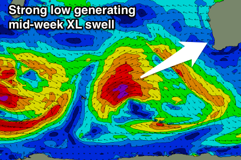
Large clean swell for Wednesday and Thursday
Western Australia Surf Forecast by Craig Brokensha (issued Monday 5th June)
Best Days: Early Tuesday Perth keen surfers, Wednesday, Thursday, early Friday keen surfers, Sunday protected spots
Recap
Large building surf over the weekend with good options in protected spots Saturday across the South West (clean and offshore to the north), while Sunday saw XL sized surf with offshore winds across all locations.
The swell eased steadily through the day, leaving still large and pumping 8ft+ surf this morning across the South West and 3ft waves further north.
This week and weekend (June 6 – 11)
The weekend's XL swell event will continue to ease through tomorrow and fresh N'ly tending NW winds will create terrible conditions across the South West. Perth and Mandurah should see a better NE breeze at dawn with lingering 2ft sets.
Tomorrow's NW winds will be associated with a significant storm approaching from the south-west.
 Currently an intense low is positioned around the Heard Island region, generating a fetch of severe-gale to storm-force W/SW winds. The low should project east-northeast towards us over the coming days, while weakening slowly, producing a large W/SW groundswell for us Wednesday and Thursday.
The swell is expected to arrive Wednesday morning, building rapidly towards 10-12ft+ by dark, peaking overnight and easing from the 10ft range Thursday. Perth and Mandurah should reach 2-3ft by dark, easing from a similar size Thursday.
Winds are looking good for Wednesday morning as the swell builds with SE offshores around Margs and E'ly breezes further north, strengthening from the S/SE into the afternoon. Thursday looks great with fresh E/NE offshore tending lighter NE winds.
Come Friday an early but gusty NE breeze will favour protected spots across the South West as the swell continues to ease, swinging stronger N'ly through the day.
This strengthening N'ly will be associated with an approaching front, with poor NW tending W/SW winds into Saturday.
Behind the front some good new mid-period and long-period W/SW groundswell are due Sunday.
The long-period energy is being generated by a strong but distant storm that's currently south-east of South Africa. This storm will move slowly east while generating severe-gale W/SW winds (storm-force at its core) before weakening in the Heard Island region Wednesday evening.
An inconsistent but moderate to large sized W/SW groundswell is due from this system, arriving Saturday and building into the afternoon ahead of a peak Sunday to an inconsistent 6-8ft+ in the South West and 2ft to occasionally 3ft further north. Also in the mix will be some mid-period W/SW energy from a weaker mid-latitude front approaching from the west late week, bringing Saturday's change.
Winds will improve Sunday but be best for protected spots with S/SE breezes due across the South West (possibly still onshore to the north). We'll have a closer look at this Wednesday though.
Longer term we're on track for a large clean SW groundswell mid-next week from a vigorous low forming in the southern Indian Ocean, but more on this next update.


Comments
indian ocean on a roll !
Great time to be camped out in Indonesia . Nothings better than a serious blob on the wams for indo .
Is there really a bigger swell next week ?
Yeah, very strong low down near Heard Island this weekend. 55-60kt core winds. Should see peak periods of 21-22s.