Poor outlook continues, light at the end of the tunnel
Western Australia Surf Forecast by Craig Brokensha (issued Monday 15th May)
Best Days: No good days, later next week
Recap
Not much in the way of surf over the weekend with small clean leftovers Saturday morning across the South West to 2-3ft, similar size Sunday but with deteriorating winds.
Today a mid-latitude low is hitting the coast bringing with it a poor messy windswell across all coasts. The first real stormy day we've had in a while across the region.
This week and weekend (May 13 – 21)
The low currently moving in across the state is even weaker than forecast Friday, with it due to move off east of us tomorrow, with not much of a trailing fetch behind it.
What we'll see is a rapid drop in size with small weak leftovers tomorrow, easing back from 3-4ft across the South West and 2ft to the north.
 Winds are looking to improve through tomorrow with strong and gusty S/SW tending S/SE breezes across the South West, similar around Perth.
Wednesday morning will be the cleanest but there'll be hardly any swell left at all with 2-3ft sets in the South West and 0.5-1ft in Perth. A fresh E/NE offshore will swing more N/NE into the afternoon.
A low point in swell is due Thursday morning and winds from the northern quadrant will create average conditions.
Now into the end of the week we're due to see a distant long-period SW groundswell generated in our far swell window, south and south-east of South Africa. This swell will build through Friday but conditions will be poor with strengthening NW tending W/NW winds as another intense mid-latitude low approaches from the west.
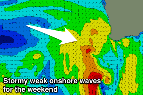
This low will project a flurry of strong W/SW winds towards us through the middle to end of this week before moving across us early Saturday morning, stalling and continuing to aim SW winds into us through the entire weekend.
 We'll see more stormy mid-period W/SW tending SW swell from this system, filling in Saturday and holding Sunday before easing Monday.
Stormy 6-8ft surf is expected across the South West with 3-4ft waves around Perth and Mandurah, possibly kicking a touch stronger later Sunday. Strong W/SW winds are due Saturday, with SW winds Sunday and lingering S/SW winds Monday as the swell eases.
Longer term a significant low pressure system is forecast to develop south-east of Madagascar over the weekend, producing a moderate to large and long-period W/SW groundswell for later next week with what looks to be offshore winds. Check back Wednesday for the latest on this.

