Poor weekend, much better into early next week as the swell fades
Western Australia Surf Forecast by Craig Brokensha (issued Friday 7th October)
Best Days: Perth and Margs Monday morning, Margs Tuesday and Wednesday mornings
Recap
Onshore winds and a building W/SW swell across the state yesterday, much better this morning with early offshores across the South West and clean, peaky easing 4-6ft sets. 2ft waves were seen to the north with N/NE winds.
This weekend and next week (Oct 8 - 14)
This weekend will be a write-off with smaller surf tomorrow and a strengthening W/NW breeze, tending W/SW later.
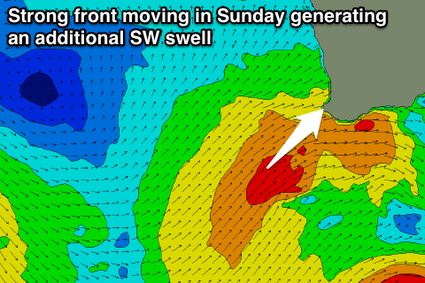
Sunday's large building mid-period W/SW swell is still on the cards, but we'll also see an additional SW swell for the afternoon, generated by another front pushing into us during the day.
With this conditions will be poor and stormy with a strong to gale-force but easing W/SW tending SW wind.
The Margaret River region should build to 6-8ft+ while Perth will see messy 3ft surf.
A drop in size is then expected through Monday 6ft to nearly 8ft, and 2ft+ in Perth.
 Conditions will be best around Perth with an E/SE offshore, with light SE winds expected around Margs
Tuesday will be the cleanest around Margs as winds tend E/SE during the morning but the swell will be small and easing from the 4ft range, with tiny waves to the north.
Wednesday morning is expected to also be clean but small, with a slight increase in inconsistent SW groundswell for the afternoon.
This swell will be generated by distant but unfavourably aligned polar frontal activity west of the Heard Island region. An inconsistent 4-6ft of swell is due into Wednesday afternoon but as sea breezes kick in, with tiny waves around Perth.
Longer term a mix of long-period and short-range W/SW swell is due into the end of the week and more so Saturday, produced by a distant polar frontal system, re-intensifying off our region once it approaches later next week. Winds will of course be onshore, but more on this Monday. Have a great weekend!

