Large onshore surf, improving Monday
Western Australia Surf Forecast by Craig Brokensha (issued Friday 15th July)
Best Days: Protected spots Monday, Tuesday morning, Perth Thursday and Friday
Recap
Terrible conditions yesterday with no real groundswell and a building NW windswell with strengthening NW winds.
Today the NW windswell was on the ease from 2ft on the sets around Perth and Mandurah, with more size in the South West. Later in the day we should see some large new W/SW groundswell impacting all regions but conditions will remain poor with a strengthening N/NW wind.
This weekend and next week (Jul 16 - 22)
The coming weekend will be plagued by onshore winds across the South West (NW Saturday and W/NW Sunday), with possible early lighter N'ly breezes in Perth, but this is more unlikely than likely.
This afternoon's late kick in W/SW groundswell should hang in around 8ft+ across the South West and 2-3ft in Perth ahead of a new large kick through the afternoon/evening.
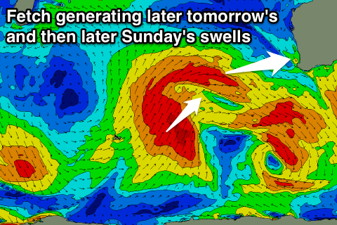
 This pulse, generated by a fetch of W/SW gales projecting towards us today on an already active sea state should see sets reaching 8-10ft on dark in the South West and 3ft in Perth.
This swell should hold into Sunday morning ahead of the largest increase in size due later in the day, peaking overnight and easing Monday.
This final pulse should be generated by a final burst of SW gales wrapping around the back of the W/SW fetch, projecting more towards us through this afternoon and evening.
Large 10ft+ waves are due to develop mid-late afternoon across Margs (larger at deep water reefs) with Perth kicking to 3-4ft.
Early Monday should reveal similar sized waves, easing back slowly through the day.
Tuesday will then see the surf easing back further from 6-8ft and 2-3ft respectively.
Winds on Monday are now set to improve as a ridge of high pressure moves in quickly overnight Sunday, resulting in S/SE breezes across the South West, SE around Perth. Protected spots will be the pick for a wave.
Into Tuesday variable winds should create favourable conditions again before a moderate W/NW'ly develops.
It won't be long between swells, with a vigorous polar frontal progression firing up south-west of us early next week due to produce two separate but closer-spaced SW groundswells Wednesday, followed by a reinforcing swell Thursday, and another Friday.
This will be due to an initial broad fetch of pre-frontal severe-gale W/NW winds, closely followed by W/SW gales, generating Wednesday's swells. Another strong front will then push over the back of this system keeping wave heights up Thursday.
The South West should come in around 6-8ft with each pulse (possibly a few bigger cleanups, with 2ft+ waves around Perth. Unfortunately onshore winds are expected through Wednesday and Thursday across the South West (better to the north) with SE winds Friday. We'll review this Monday though. Have a great weekend!

