Great tomorrow and Wednesday, larger swell Saturday but with dicey winds
Western Australia Surf Forecast by Craig Brokensha (issued Monday 7th March)
Best Days: Perth and Margs tomorrow morning, Margs Wednesday morning, Margs Friday morning and both regions Saturday morning
Recap
Tiny waves across Perth and Mandurah through the weekend, with better and clean waves in the 3ft range across the South West each morning.
Today a couple of new pulses of SW groundswell due across the state came in a lot bigger than expected this morning across the South West. From dawn easy 4-6ft sets were breaking across the region, with bigger bombs seen through the morning under offshore winds. These bigger sets must have been from the core 45kt wind speeds seen in the W/NW fetch responsible for the swell.
Perth and Mandurah remained tiny, but we've seen a slight kick this afternoon with better 1-2ft sets showing around Mandurah, with 1.5ft waves around Perth.
This week (Mar 8 - 13)
With this morning's initial increase in SW groundswell coming in above forecasts, it's easy to over-react and increase the size of the swell due this afternoon and tomorrow morning across the coast.
But as they are separate events, created by different frontal systems I feel no major correction is needed for tomorrow morning, with a slowly easing SW groundswell from the 6ft range on the sets, down further from 3-5ft Wednesday morning.
Perth should see inconsistent 1-2ft sets tomorrow morning, tiny into Wednesday and Thursday.
Conditions should be great tomorrow morning with a light to moderate E/NE offshore ahead of afternoon sea breezes, similar Wednesday, while a shallow S/SW onshore change is due into Thursday.
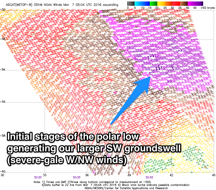
 Our larger SW groundswell event for Friday afternoon and Saturday morning is still on track, with a strong node of the Long Wave Trough set to move in from the west over the coming days, bringing with it a strong polar frontal progression.
We've already seen a strong polar low develop south-west of Heard Island, generating a fetch of pre-frontal W/NW gales. This low should traverse east along the polar shelf, while continuing to generate a fetch of W'ly gales before weakening and projecting north-east towards us and then onwards towards the Bight late week.
An initial increase in SW groundswell is due through the late morning Friday ahead of a late kick in long-period energy. Exposed breaks in the South West should reach an easy 5-6ft+ later in the day, but not make any real impact around Perth, with a peak Saturday morning to 6-8ft with 10ft bombs. Perth should offer inconsistent 2ft sets.
Offshore E/SE winds are due Friday morning ahead of afternoon sea breezes, while Saturday looks a little dicey with S/SE breezes now on the cards. We'll have a closer look at this Wednesday though.
Longer term moderate pulses of SW groundswell are due through next week, but more on this Wednesday.


Comments
Looking excellent this morning down across Margs!