Good clean swell Wednesday, easing through the week as winds deteriorate
Western Australia Surf Forecast by Craig Brokensha (issued Monday 29th February)
Best Days: Wednesday morning, Thursday morning, Monday, Tuesday and Wednesday mornings in the South West
Recap
Good clean fun options Saturday with an easing S/SW swell from 3-4ft, with decent conditions continuing into the afternoon as winds tended more variable.
Sunday was smaller and average as an onshore change moved through, while today the swell bottomed out with early variable winds. Perth and Mandurah have remained tiny to flat the last few days.
This week (Mar 1 - 4)
A small increase in weak windswell is due this afternoon with some better mid-period swell due tomorrow ahead of a less consistent SW groundswell later in the day, peaking Wednesday.
The source of these swells was initially a strong but weakening polar front pushing up and towards the region the last few days. The front has raced ahead of the swell it was producing resulting in the increase in shorter-period windswell ahead of the groundswell.
 Small weak 3ft+ waves are due most of tomorrow in the South West, ahead of a late kick in groundswell to 4-5ft.
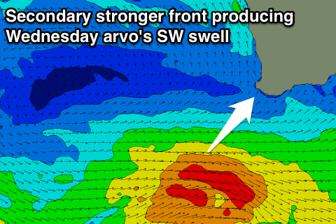
A peak is due Wednesday morning to 4-5ft+, but another stronger front firing up on the back of the weakening front tomorrow should produce a better pulse of SW groundswell for the afternoon to 4-6ft.
Perth isn't due to see any real size until Wednesday with inconsistent 1-1.5ft sets likely, possibly kicking to 2ft on the sets through the afternoon before fading from 1-1.5ft Thursday.
Conditions tomorrow won't be the best with S/SE breezes, but Wednesday looks nice with morning offshore E/SE winds ahead of afternoon sea breezes. Winds are then due to return to the SE Thursday morning as the swell eases from 3-5ft in the South West.
Friday isn't looking too flash as the swell continues to ease with less than ideal S/SE winds.
A couple of small SW groundswell pulses are due through Saturday afternoon and Sunday from weak polar frontal activity, but not above 3ft or so in the South West and with SE-E/SE winds.
Later in the day Sunday and more so Monday a better SW groundswell is due to fill in across the state, generated by a vigorous fetch of severe-gale to storm-force W'ly gales developing under and east of Heard Island.
The track isn't ideal but we should see inconsistent but strong 4-5ft of swell for Monday morning as winds swing offshore. Perth isn't likely to offer much other than 1-1.5ft sets.
A secondary similar sized but likely more consistent pulse is on the cards for Tuesday with a better aligned but weaker front moving through our swell window.
Winds look good and from the E/NE as well, with NE breezes Wednesday as the swell eases.
Longer term there's still nothing major on the cards for our region, but check back here Wednesday for more details on this.


Comments
Looking great across the South West this morning!
Old mate out the back is on a decent sized bomb.