Mediocre run continues
Western Australia Surf Forecast by Craig Brokensha (issued Friday 26th February)
Best Days: Wednesday morning, dawn Saturday swell magnets
Recap
Tiny waves around Perth and better 3-4ft sets in the South West with improving winds all day ahead of mid-afternoon sea breezes.
Today the swell has held a similar size with a new S/SW swell keeping 3-4ft sets hitting swell magnets with strong offshore winds.
This weekend and next week (Feb 27 – Mar 4)
Winds are looking a little dicey now tomorrow with an easing S/SW swell from the 3ft range. Dawn E/SE breezes are expected to swing S/SE, creating average conditions.
Sunday looks smaller now and with average morning S/SW winds continuing, so it's not the best looking weekend.
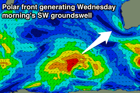
Monday will start tiny and with a developing onshore breeze as a weakening polar front pushes up and towards us.
 The swell off this front is due later Tuesday and Wednesday morning, but before this some short-range weak windswell is expected to build later Monday and into Tuesday but only to 3-4ft or so.
The better groundswell should kick later in the day to 4-5ft around Margs and peak Wednesday morning to 4-5ft+, easing through the day. Perth isn't due to see much size with tiny 1-1.5ft waves Tuesday, if that, with inconsistent 1-2ft sets Wednesday morning.
Conditions will remain average Tuesday as winds tend S/SE, while Wednesday looks great with offshore E/SE breezes.
A slow easing trend is due through the end of the week, with secondary weak frontal activity producing small reinforcing SW energy. Winds look to return to the SE though which isn't ideal.
Longer term there's still nothing major standing out on the charts for our region, which is a real bummer. Check back Monday for an idea on when this may change. Have a great weekend!

