Building stormy swells with onshore winds, cleaning up late week
Western Australia Surf Forecast by Craig Brokensha (issued Monday 16th November)
Best Days: Dawn Tuesday around Margs if we're lucky, Friday morning, Saturday mid-morning onwards, Sunday morning
Recap
Clean fun easing surf Saturday from 4-5ft in the South West and 1-2ft around Perth while yesterday was poor with onshore winds and a small leftover swell.
A slight kick in new W/SW swell has been seen today to 3-4ft around Margs, while Perth continued in the tiny 1ft range. Conditions were clean again this morning but onshore sea breezes have just moved in.
This week (Nov 17 - 20)
Today's slight kick in W/SW swell across the South West will be reinforced by a slightly bigger but inconsistent pulse tomorrow morning to 3-5ft. Perth is due to remain around the tiny 1ft range.
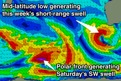
Unfortunately a deepening mid-latitude low moving in from the west will bring early onshore NW winds to both coasts, with only a very slim chance for a dawn E/NE'ly. These winds will swing more W/NW through the day along with a building windswell due into the afternoon (reaching 1-2ft around Perth late).
 Into Tuesday and Wednesday the mid-latitude low is forecast to aim a fetch of strong to gale-force W'ly winds through our swell window, with a weakening fetch of S/SW gales on the backside of the low moving through Wednesday evening.
This should produce moderate to large levels of short-range W/SW swell, building through Wednesday and then easing out of the SW tending S/SW Thursday.
Margs should build to a stormy 6-8ft later Wednesday along with fresh to strong W'ly winds, easing from a similar size range Thursday morning with fresh SW tending S/SW winds.
Perth should kick to a stormy 2-3ft Wednesday afternoon and then hold around 2-3ft Thursday, backing off rapidly from 2ft Friday morning. This is when conditions will be cleanest as winds swing E/SE (SE around Margs).
This weekend onwards (Nov 21 onwards)
Saturday morning is expected to be a low point in swell activity, but a good new SW groundswell is due to fill in through the day and peak into the evening, generated by an east-southeast tracking polar frontal progression from the Heard Island region mid-late week.
This groundswell will favour Margs over Perth, with exposed breaks due to kick to 5-6ft through the afternoon, with 1-1.5ft waves later in the day around Perth, backing off slowly Sunday and further Monday.
Conditions are looking good though if not a little blowy with a moderate to fresh E'ly Saturday morning ahead of afternoon sea breezes and then stronger E/SE winds Sunday morning. Into early next week strong S/SE winds and smaller easing levels of swell won't leave too many options.
Longer term a blocking high will deflect any major storms away from us resulting in a slow run in swell. We'll have another look at this Wednesday though.

