Fun Saturday, good surf through next week after dicey winds Monday
Western Australia Surf Forecast by Craig Brokensha (issued Friday 16th October)
Best Days: Saturday, Monday protected spots both coasts, Tuesday morning, Wednesday, Thursday morning
Recap
Strong swell yesterday but poor conditions across all coasts with onshore winds. Today the swell was backing off, with onshores continuing across the South West but cleaner conditions to 2ft around Perth.
This weekend and next week (Aug 17 - 23)
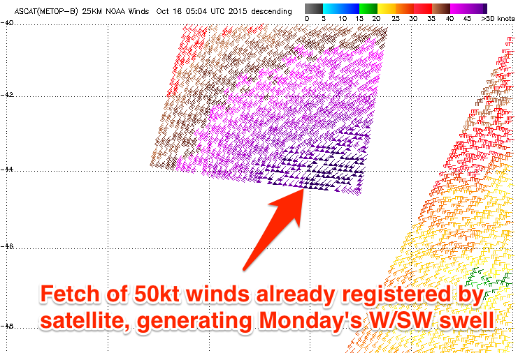
Our two pulses of strong SW and then W/SW groundswell for tomorrow and later Sunday/Monday are still on track, but winds are a little suss now for Monday.
Firstly a strong low to our south-west has produced a fun SW groundswell for tomorrow morning, with the South West due to come in at 6-8ft with 2ft sets in Perth under light to moderate E/NE offshores, ahead of S/SW sea breezes.
Sunday will then be smaller and average with an approaching front spawning off the low linked to Monday's swell due to bring onshore NW tending W/SW winds.
 This low is now due to hold its strength a little longer and closer to us, producing a larger W/SW groundswell for later Sunday, peaking Monday. The size will come from a fetch of gale to severe-gale W/SW winds projected towards us, generating large 6-8ft+ waves across the South West and good 2-3ft surf across Perth.
Winds unfortunately look to be SW across Margs, but S/SE early around Perth if we're lucky, limiting the best waves to protected spots.
Tuesday will be much cleaner with E/SE offshores and easing from 4-6ft in the South West and 2ft around Perth.
A small to moderate sized reinforcing SW groundswell is due Wednesday morning, generated by a persistent fetch of strong to gale-force W/NW winds moving in behind the low responsible for Monday's swell.
This should keep 4-5ft sets hitting the South West and 1ft to occasionally 2ft sets around Perth with E/SE offshores, likely just tending variable into the afternoon.
Later in the day though we should see a new moderate sized SW groundswell starting to move in, produced by a broad but relatively weak polar frontal system firing up in the Heard Island region on Sunday. The front will stay at polar latitudes, limiting its swell potential, but we should still see 6ft+ sets across the South West at its peak Thursday morning with 2ft waves around Perth. Winds are looking favourable and offshore ahead of a W'ly change through the day.
Longer term, small to moderate pules of SW swell will continue through the end of the week and into the next weekend but with less favourable winds. More on this Monday. Have a great weekend!


Comments
Looking big and roguey at Yalls this AM.