Large and offshore on Sunday
West Australian Surf Forecast by Guy Dixon (issued Wednesday 16th September)
Best Days: Thursday, Sunday, Monday
Recap:
There were good options right along the coast on Tuesday with generally light offshore winds, clean set-ups and modest size.
The surf held in the 4-5ft range throughout the day across the South West with light south/southeasterly winds tending east/southeasterly in the afternoon. Conditions were good along the Perth and Mandurah stretches with surf in the 1-2ft range and light southeasterly winds prevailing throughout the day. Winds swung round to the south/southeast late for Mandurah, but remained easily workable.
It has been a similar situation today, with the Mandurah holding in the 1-2ft range and Perth in slowly easing back to the 1ft range. Winds remain light offshore and conditions are clean. Similarly, the South West has been clean offshore in the 3-5ft range with only a light north/northeasterly breeze coming up this afternoon.
This week (Thursday 17th - Friday 18th):
Thursday will see a mixture of swells in the water. One swell will have a very long period, generated by a long range system well west of Heard Island earlier in the week, but not much size to speak of. The second swell will have a more modest period, but will have dominate in the size department. All in all, the surf is likely to be in the 4-5ft range across the South West throughout the day, with the odd inconsistent bigger set when the longer period swell shows it’s self occasionally.
Perth and Mandurah aren’t likely to see much size off this swell, likely sitting in the 1-2ft range.
The morning session is looking good with light easterly winds right along the coast, before tending northeasterly (moderate over the South West) and eventually variable onshore in the afternoon.
This long range swell from the western Indian Ocean will peak on Friday providing surf in the 5-6ft range across the South West and with better consistency. Perth and Mandurah will most likely hold in the 1-2ft range, with the odd bigger set. The late session across the South West also has the potential to see a touch more energy off a poorly aligned northwesterly pre-frontal fetch, however the effects will be hard to decipher and late in the day.
Winds will be largely dependent on the axis of a trough on Friday morning. There is fairly good model consensus that the South West will be under a strengthening onshore flow from day break (the very early birds may get light variable winds for a brief period). Winds will be light westerly early, tending west/southwesterly and freshening so the morning session is the best window of opportunity for the day.
As for Perth and Mandurah, there is likely to be a period of light northeasterly breezes early as the trough lingers offshore. From late morning/early afternoon, winds will swing southwesterly (Mandurah first), before freshening in the evening.
 This weekend (Saturday 19th - Sunday 20th):
The surf will build steadily into the 6-8ft range across the South West throughout Saturday generated by a good sized fetch of southwesterly gales ahead of the main swell generating core winds. Perth and Mandurah will see sets in the 2ft range in the afternoon.
Much of the WA coast will be under a gusty south/southeasterly air flow following a front which will have moved through overnight limiting options to the protected spots. These breezes look to weaken slightly (particularly across the Metro stretch) in the afternoon allowing for marginally better options.
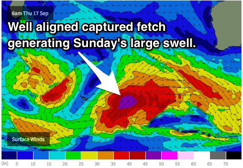
As the system intensifies throughout Thursday east of Heard Island, a southwesterly captured fetch of 45-50kts will move in good alignment to the South West. The surf is likely to peak on Sunday morning in the 10-12ft range across the South West and 3ft for Perth and Mandurah, easing throughout the afternoon.
A ridge should have become established over the South West allowing for light east/southeasterly winds early, tending southerly late. Perth and Mandurah will see a slightly more gusty air flow from the southeast (where the isobars tighten up around a weak trough), tending moderate southerly late.
Next week (Monday 21st onward):
The surf will ease off the back of Sunday’s pulse on Monday morning, however the next swell front is likely impact the South West that afternoon generated by system following closely behind.
This system shows slightly stronger core winds, but the alignment isn’t as favourable and it the fetch isn’t moving in the same direction as the swell it’s generating. It will however be working on an active sea-state which will aid swell generation. Despite all these factors, this pulse is likely to provide surf in the 8ft+ range for the late session across the South West but looks to arrive too late for Perth and Mandurah, leaving them with 1-2ft left overs.
Winds look good right along the coast with moderate easterly breeze until mid afternoon, easing and possibly tending southeasterly late.
Tuesday will see this swell gradually ease to around 6ft, further on Wednesday only slowed by back ground energy generated by relatively insignificant systems passing through the swell window on Monday.

