Yet another weekend swell on the cards
West Australian Surf Forecast by Guy Dixon (issued Monday 14th September)
Best Days: Wednesday, Thursday morning, Saturday and Sunday
Recap:
The weekend saw a large swell plagued by relentless fresh/strong onshore winds.
The surf built to from 6-8ft across the South West to a late 10-12ft, but there were no surfable options with fresh/strong winds blowing anywhere from west/northwesterly through to southwesterly throughout the day. Sunday wasn’t great, but winds had enough south in them for the protected spots to offer a semi-decent wave. Size wise, the swell eased to around 8ft by late in the day.
As for Perth and Mandurah, fresh onshore winds labelled Saturday a write off despite the surf building to around 3ft. Sunday morning offered a window of opportunity with winds dying and tending offshore for about 1-2 hours first thing.
This afternoon, Metro beaches are picking up sets in the 2ft range with onshore breezes remaining light enough not too be causing too many issues. As for the South West though, the surf has faded to around 4-6ft but is still pretty choppy and disorganised under a gusty southwesterly breeze. Only the most protected spots are offering a wave of variable quality.
This week (Tuesday 15th - Friday 18th):
The next few days look to be fairly quiet along the WA coastline with only weak and insignificant swell fronts filling in. Tuesday morning will see a subtle period pulse generated by southwesterly trailing fetches which followed off the back of the weekend’s swell generating system. Size wise, the increase in size will be negligible, it looks more likely for the South West to hold in the 4-6ft range throughout the day, easing slowly throughout Wednesday afternoon.
Perth and Mandurah aren’t likely to see much love off this system, with the surf fading back to the 1ft range on both days.
Winds will prevail from the southeast across all coasts throughout Tuesday, tending south/southeasterly and lightening in the afternoon. Wednesday is looking good with light/moderate easterly winds across all coasts, easing and tending variable late.
Thursday afternoon will see the next most significant period pulse generated by very long range system below South Africa somewhere, but the size with this swell is measly. Generally speaking the surf will continue to ease back to the 4-5ft mark across the South West with the occasional bigger set rolling through every so often. Metro beaches will pick up surf in the 1-2ft range.
Right along the coast, winds should prevail from the east early, tending northeasterly around lunchtime before becoming light and variable late (the South West has the potential to see a late northerly breeze).
Friday will see a touch more energy as the long range groundswell peaks, buping the surf to the 4-6ft range, while Perth and Mandurah hold in the 1-2ft range. Friday’s winds are a little more dynamic as a pre-frontal trough moves over the region. The South West will be under a light northeasterly airflow preceding an increasing southwesterly change from the early afternoon. As for Perth and Mandurah, winds will initially be moderate northeasterly, tending light northwesterly and eventually right through to southwesterly by dark. Essentially it will be a slower change compared to the South West.
 This weekend (Saturday 19th - Sunday 20th):
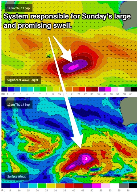
A promising looking fetch of west/southwesterly severe gales will move south of Heard Island on Thursday, intensifying that evening and into Friday with core winds forecast to reach 50-55kts. The long period forerunners of this system will make landfall across the South West on Saturday afternoon providing a late kick of inconsistent to 6-8ft across the South West and 2ft for Perth and Mandurah.
Sunday will see the bulk of the of the size fill in (which seems to have happened a lot this season), kicking to a solid 10ft with a few 12ft sets thrown in for good measure. The direction of this swell is not optimal for Perth and Mandurah, however there is plenty of energy in the water which should provide 2-3ft surf. As the week progresses we will monitor how models handle this system and adjust the size/timing accordingly.
In contrast to the last few weekend swells, winds are looking to be more manageable. Saturday will see a fairly gusty moderate/fresh south/southeasterly airflow across all coasts, tending southeasterly late providing a fair few options at selected locations, especially as we see a few bonus late bombs.
However Sunday really looks to be the best day with better winds and more size. Winds will be of a similar moderate/fresh strength (lighter towards Perth and Mandurah) however prevailing from the east in the morning, tending southeasterly late.
At this stage, this is the pick of the week.
Next week (21st onward):
Early next week doesn’t hold many prospects of fresh swells. The longer term out look suggests that the swell will gradually ease off the back of Sunday’s pulse with favourable/workable winds until mid-way through the week under a weakening ridge and deepening ‘summer-looking’ trough.

