Terrible week ahead, save it for the weekend. Potential big swell long term
West Australian Surf Forecast by Guy Dixon (issued Monday 17th August)
Best Days: Saturday and Sunday.
Recap:
We saw the best surf in a long time across the South West on Saturday with waves in the 5-6ft range and light/moderate southeasterly winds keeping everything in order. Perth and Mandurah picked up to around 2ft with clean peaks under light easterly winds. The surf faded slightly by Sunday, however there was still plenty of options Across the South West in the 3-5ft range under light/moderate east/southeasterly breezes. Metro beaches eased back to the 1-2ft mark, but remained nice and groomed under offshore breezes.
This week (Monday 17th - Friday 21st):
The synoptic set up over the coming week is dynamic to say the least. Describing the synoptic set up is near impossible. The best way to visualise it is to head to the South Oz WAMS (http://www.swellnet.com/reports/australia/south-australia/middleton/wams) and pay particular attention to the MSLP chart on the bottom right.
A cut-off low is passing to the south/southwest of Cape Leeuwin this afternoon/evening. The northern flank of this system is causing northerly winds to gradually tend more onshore and strengthen this afternoon right across the coast from Perth to the South West.
As a result, the inconsistent 3ft conditions which we saw across the South West this morning are now chopped up and not worth even considering, while Perth and Mandurah will have likely turned to 1ft junk by later this afternoon.
Tuesday will be a write off right along the coast with fresh/strong westerly winds persisting all day and virtually no decent options.
Come Wednesday morning, a second low is looking to approach the South West, directing a moderate/fresh westerly flow throughout the morning, strengthening in the late afternoon. As the day wears on, this system will decay and interact with the previous system (which by this stage should be located off the Esperance coast) creating an elongated low/trough.
It seems trivial to mention a pulse of swell with all this wind, but Wednesday is likely to see a very subtle pulse of southwesterly swell, bumping the swell from around 2-3ft to 3-4ft across the South West. Perth and Mandurah will continue to see choppy 1ft conditions.
Thursday will see a gusty southwesterly flow right across the coast in the wake of the second low, followed up soon after by a weak cold front (due after dark). Perth and Mandurah will see peaky 2ft waves generated by a westerly fetch associated with the low offshore the previous day.
Unfortunately, Friday doesn’t hold any better news with fresh/strong southwesterly winds persisting in the wake of the cold front killing any significant chance of a decent wave. A long range ground swell will fill in, however the Saturday will see the best results from this pulse.
This weekend (Saturday 22nd - Sunday 23rd):
Saturday will bring the next best chance of a (relatively) decent window of opportunity. We should see Friday’s southwesterly ground swell generated by southwesterly trailing fetch moving east of Heard Island mid-week, combining with a shorter range wind swell generated by a front/cut-off low passing to the south of Cape Leeuwin. The surf should kick to around 6ft+ across the South West while Perth and Mandurah should see peaks in the 2ft range.

The South West will be under a moderate/fresh southerly flow all day, easing in the afternoon which looks to be the best window of opportunity. Winds across the Metro Beaches will be much lighter, south/southeasterly in the morning, tending south/southwesterly in the afternoon but remaining light.
The surf will fade throughout Sunday from 4-6ft across the South West and back to 1-2ft for Metro beaches. Winds will be light east/southeasterly for Perth and Mandurah in the morning, tending light south/southwesterly in the late afternoon. The South West is looking at light southeasterlies, swinging south/southwest in the afternoon, but remaining fairly light.
Next week (Monday 24th onward):
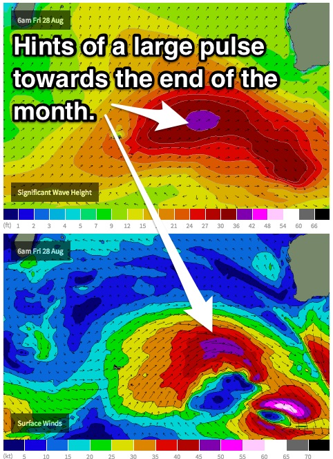
We are looking at a similar sized pulse for mid-way through next week, but the most enticing period is late in the week and into next weekend where the Indian Ocean is looking particularly active. There are indications of the strongest frontal progression since the ‘XXL swell of the decade’ a couple months ago. At this stage, we are hoping for a kick to 10-12ft, but at the same time lets play it safe and keep monitoring it.

