Plenty of swell, winds aren't cooperating. Next week looks better
West Australian Surf Forecast by Guy Dixon (issued Friday 7th August)
Best Days: Tuesday, Wednesday.
Recap:
Small clean conditions across the South West this week with the swell magnets picking up the odd 2ft peak on Thursday under light easterly breezes. The surf lifted slightly today with clean peaks in the 2-3ft range but remaining pretty inconsistent. Fortunately the winds remained light offshore until just after lunch, and we are starting to see an onshore flow dominate this afternoon.
Perth and Mandurah have been near enough flat, with barely surf able 0.5-1ft waves breaking right on the shore. Winds have been generally offshore allowing for clean conditions, tending northerly in the afternoons creating a few small lumps.
 This weekend (8th August - 9th August):
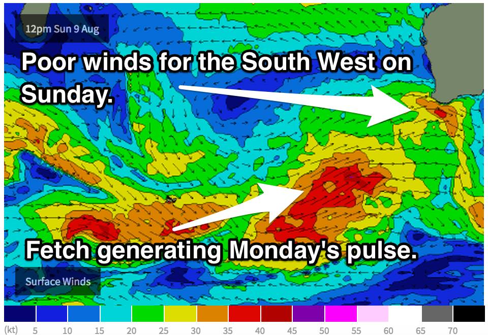
We have been a bit deprived in the swell department for the past week and we are awaiting a kick in size this weekend. Saturday afternoon will see the first impacts of a fresh southwesterly ground swell generated by a broad frontal progression which has been moving east of Heard Island in the past few days.
Within the broader system, there have been smaller scale lows which have produced small fetches of severe gales. The longer period forerunners generated by these intense fetches will lead to surf building into the 4-6ft range across the South West late on Saturday, and 1-2ft for Perth and Mandurah.
Saturday as a whole will be pretty much a write off right along the WA coast line. A fresh southwesterly flow will persist from go to whoa steered by a strong cold front. There will be very few surfable options and is barely worth considering.
Sunday will see the bulk of the swell fill in (actually a second pulse in the morning), with the underlying ground swell providing 6-8ft+ surf across the South West. Fresh/gale force winds offshore the day before will also add an element of short range wind swell into the mix.
Further north, the metro beaches can look forward to 2ft ground swell with an addition couple of feet of short range wind swell on top. We have been keeping a close eye on the winds for the stretch of coast from Mandurah to Jurien Bay on Sunday morning and the situation had been improving with each model run - but now, I'm not so confident.
The latest run of EC (one of the more trustworthy models) has now gone back to the original scenario with moderate west/southwesterly breezes from sunrise right along the coast with only a brief window of opportunity at the 11am time step (light northeasterly winds). GFS has northeasterly breezes at the 11am time step, tending more northerly as the afternoon takes hold and eventually onshore. If I was a betting man, I’d put my money on it being pretty dicey. If you were contemplating driving north, there is a low-moderate chance of getting a window of favourable winds in the late morning, but it would be brief and surface conditions are likely to be bumpy from the night before.
The South West will be under a moderate southwesterly flow from the get go. Don’t get your hopes up for any decent quality on this day, as there will be barely any options to choose from that aren’t wind affected.
Next week (10th August onward):
The southern Indian Ocean is looking pretty active in the coming days resulting multiple pulses of swell which should not only slow the easing trend, but prevent the surf from dropping below 4ft across the South West for the best part of next week.
Off the back of the weekend swell, Monday will see the surf ease back slightly to the 6ft+ range across the South West, before a fresh pulse fills in on Tuesday morning. Tuesday’s swell isn’t likely to result in a kick in size, but instead slow the easing trend and maintain a pretty solid 6ft+ for the remainder of the day.
Another, smaller pulse will fill in on Wednesday, again not adding any size but instead maintaining 4-6ft swell across the South West. Perth shouldn’t should below 1-2ft from Monday until Wednesday.
I hate to be the bearer of bad news, but even Monday is looking poor in terms of wind. Nothing but southwester lies in the wake of a front. It’ll be a similar scenario to Saturday right along the coast, with little to no options to recommend.
Tuesday brings another dicey day, but a slight improvement with moderate winds easing from south/southwesterly across the South West (not ideal but workable for protected locations). The Metro beaches will be under southerly cross shore flow all day.
Wednesday is looking like the next best day of winds with light/variable-offshore along the Perth stretch, and light variable-onshore for the South West.
The longterm outlook shows an easing trend in swell, with subtle pulses here and there. I hope the weekend is good to you and if take your chances on driving north on Sunday I’d love to hear how it goes!


Comments
I hope to post a screenshot of the latest model run regarding Sunday's winds later on this evening. Stay tuned.
Odd. Give this a shot!
http://imagebin.ca/v/2BQR3qnms5hm
Cheers