Slow week, big weekend but poor winds
West Australian Surf Forecast by Guy Dixon (issued Monday 3rd August)
Best Days: Tuesday Wednesday, Thursday, Friday, Monday, Tuesday
Recap:
Saturday saw a fresh south swell fill in producing solid surf across the South West. This swell was generated from a low latitude system which meant that the acute southerly swell direction led to a distinct difference in size across the coast. Exposed parts of the South West easily picked up the most size with surf in the 6ft range, while more protected locations ranged between 4-6ft. Residents of Perth and Mandurah missed out on any notable kick in size.
Much of the WA was under a southeasterly breeze all day on Saturday, easing and tending more easterly throughout Sunday. The swell also backed off throughout Sunday dropping to around 4ft across the South West by evening.
This week (Monday 1st - Friday 7th):
As discussed in the last few forecasts, the working week is looking to remain pretty dormant surf-wise.
This afternoon, inconsistent sets in the 3ft range are filtering in across the South West as we see the weekends’s southwesterly ground swell fade. Models suggest a small and subtle pulse to around 3-4ft late this afternoon generated by the weekend’s polar activity. Again, the swell direction will be the most notable factor of this swell limiting any kick in size to the more exposed south swell magnets. Elsewhere will virtually miss out on any increase in size.
The remainder of the working week will see slight ebbs and pulses of background surf in the 3-4ft range from systems way out in the Indian Ocean.
A stable ridge of high pressure is looking to dominate over the western parts of the continent for the majority of the working week up until late Thursday as a trough/low deepens offshore. This ridge will steer persistent breezes gradually swinging from east/southeasterly this afternoon to northeasterly on Thursday. Conditions should be clean all day everyday for most locations, before becoming dicey on Thursday morning across the Perth stretch.
As a front approaches on Friday, winds will be light and variable across the South West, swinging gusty onshore as the afternoon progresses. Perth will be under a north/northeasterly flow from day break, deteriorating as the day wears on.
 This weekend (Saturday 8th - Sunday 9th):
The weekend holds the best chance of a serious kick in swell, the only limiting factor will be winds.
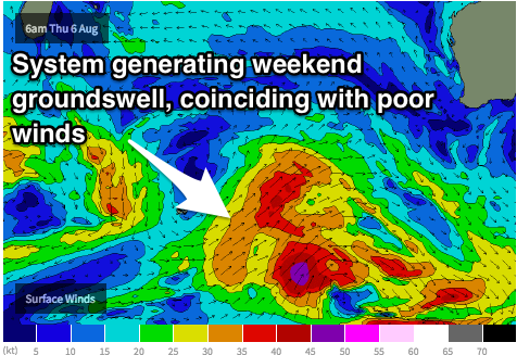
A sustained and broad frontal progression is looking to develop west of Heard Island on Tuesday/Wednesday. Winds don’t look to be overly strong as a whole (gales with a few small severe gale fetches at times), however it’s sustained nature will allow for some healthy swell generation.
A small scale low ahead of the main west/southwesterly fetch will result in an initial pulse late on Saturday afternoon with a southwesterly ground swell in the in the 4-5ft range for the South West. A larger pulse on Sunday afternoon will fill in generated by the broader frontal system will ensue bumping the size of the ground swell up to around 8ft. Metro beaches can expect a jump to around 2ft on the Sunday afternoon.
Now it’s important to note that there will be a pair of fronts crossing at the same time which will add an element of wind swell into the mix. This means that the actual surf across the South West could be up around 10ft on Sunday, while Perth could see choppy short range 2-3ft surf.
The passage of these fronts is likely to ruin the chance of any quality surf across the weekend. For much of Saturday, winds will be fresh south/southwesterly, easing into the evening. Even the most protected locations are really going to struggle on this day.
There is a very brief window of opportunity on Sunday morning (we’re talking sunrise) where winds will be light and variable ahead of the next front. Along the coastal fringe of Perth and Mandurah, winds should tend east/northeasterly. The South West could get a light variable/light onshore breeze from the get go (best case scenario), before quickly deteriorating.
We can only hope models slow things down to get a better window of favourable winds, but don’t hold your breathe because there is likely to be a heap of scarring from the previous days winds.
Next week (Monday 10th onward):
Early next week will see the surf fade from the weekends large swell event. However, a weaker southwesterly fetch following the aforementioned system will keep the surf in the 6ft range on Monday and Tuesday.
Now this is getting to the stage where models struggle with the accuracy of local scale wind forecasting, but early indications look as though the South West will be under a moderate south/southeasterly flow. In other words, winds look to be workable with a bit of hunting around and there should be a bit of size to work with too. Perth and Mandurah are looking at light/moderate southeasterly winds with surf in the 1-2ft range.
Longer term, we should see plenty of strong frontal activity bringing plenty of swell but onshore winds.

