Good infrequent swell Sunday with favourable winds
Western Australia Surf Forecast by Craig Brokensha (issued Wednesday 4th March)
Best Days: Exposed breaks Thursday morning, all coasts Friday morning, Gero Saturday morning, all coasts Sunday and Monday mornings
Recap
Fun but easing surf across the South West and Gero yesterday, while Perth was getting a little to small with 1ft to sometimes 2ft sets.
This morning the swell was even smaller and only decent at more exposed coasts across the state as winds were best mid-late morning.
This week (Mar 5 - 6)
The surf will continue to ease through tomorrow but winds will be great for exposed breaks in Margs and up at Gero with a moderate to fresh E/NE breeze through the morning.
Into Friday our small mix of new inconsistent W/SW groundswell for the morning (from ex-TC Glenda) and SW groundswell for the middle of the day/afternoon is still on the cards with exposed spots in Margs expected to offer 3-4ft sets, with 1-2ft waves in Perth and 2ft+ sets up at Gero.
E/SE winds should create clean conditions in the South West with better E/NE winds to the north.
 This weekend onwards (Mar 7 onwards)
Saturday will see Friday's mix of swells drop away with winds tending back to the SE across the South West and E/SE further north, leaving limited options.
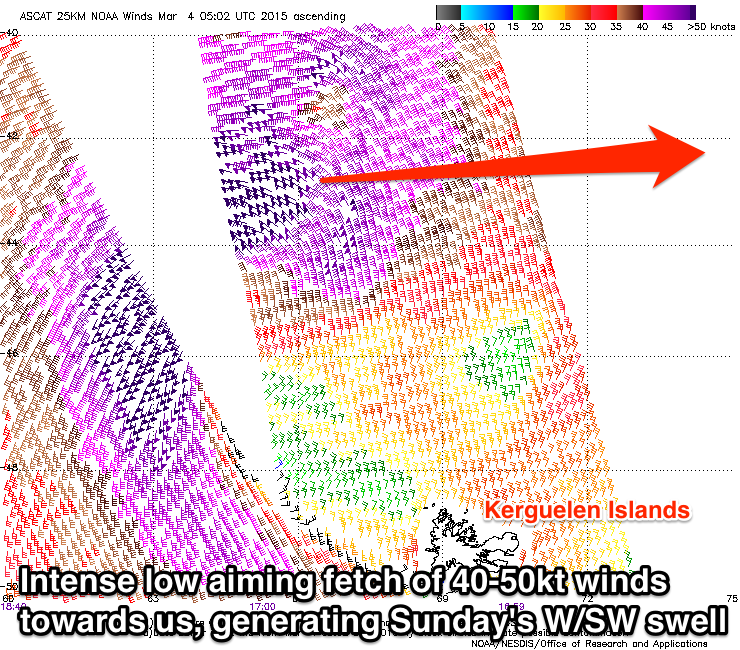
A new inconsistent but good W/SW groundswell due through Sunday is still on track, with the strong but distant low generating this swell currently producing a fetch of severe-gale to storm-force W'ly winds while tracking unfavourably to the south-east.
This should produce a long-period but inconsistent W/SW groundswell arriving overnight Saturday and peaking through Sunday.
Margs should offer inconsistent but strong 4-6ft sets at exposed breaks, with infrequent 2ft sets in Perth and 3-4ft waves up at Gero. ** The swell might not possibly be there at dawn from Perth north, but should be in by mid-morning.
Conditions should be good through the morning with E'ly and even E/NE winds around Perth and Gero, while Margs looks to see SE-E/SE breezes ahead of afternoon S/SWers.
A secondary SW groundswell that was due into Sunday afternoon and Monday off the secondary developments of the low generating the initial W/SW groundswell has been downgraded a touch in size and will now also come from the S/SW.
In general we'll see easing wave heights from Sunday, dropping from 3-5ft around Margs Monday morning, 1-2ft in Perth and 3ft up at Gero under E/SE winds.
Longer term we're looking at some fun S/SW groundswell pulses through next week as a series of strong but not too favourably aligned polar fronts develop in the Heard Island region and project north-east towards South Oz.
We'll see side-band S/SW energy hitting the Margs region best with persistent SE-E/SE winds. More on this Friday though.

