Easing surf with good winds
Western Australia Surf Forecast by Craig Brokensha (issued Wednesday 24th December)
Best Days: Every day up until Sunday morning
Recap
Yesterday was fun across exposed breaks across the state as morning SE winds swung more E'ly through the morning before onshores kicked in. Although the Margs region saw winds swing more NE and ease off into the afternoon before S/SE'ly breezes kicked in late.
Today a strong new SW groundswell has peaked with 6ft+ sets in the South West, 1-2ft waves around Perth 3-4ft sets up at Gero under SE tending E/SE breezes.
 This week and weekend (Dec 25 - 28)
Today's good pulse of SW groundswell will ease off this afternoon and further through tomorrow and Friday morning.
Winds will remain favourable and offshore from the E/SE tomorrow morning and then lighter and straighter from the E around Perth and Margs Friday morning.
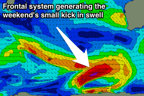
Some new SW groundswell is expected to arrive through Friday afternoon ahead of a better pulse Saturday generated by a strong but unfavourably aligned polar frontal progression pushing along the polar shelf and to our south-west last night and today.
A slight increase Friday afternoon should be followed by a better pulse Saturday reaching 3-5ft in the South West later in the day, 1-1.5ft in Perth and peaking pearly Sunday morning to 2-3ft up at Gero.
Winds will continue to be favourable and offshore from the East Saturday morning but as the swell eases Sunday we'll see fresh S/SE winds kick back in.
Monday onwards (Dec 29 onwards)
There's still nothing major on the cards for next week with the storm track remaining unfavourable for any major swell generation for our state. We'll see cold fronts deflected from the Indian Ocean down towards the polar shelf and then towards next week which isn't favourable at all.
Winds won't be too good for exposed locations either with a stationary inland heat trough directing persistent SE-S/SE winds across the state. More on this Friday though.
It's also worth noting that a weak tropical cyclone is forecast to form in the Cocos Island region over the coming days but we won't see any swell generated for our coast from this system.

