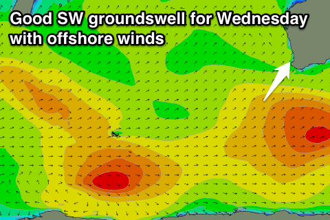
Good week of waves ahead
Western Australia Surf Forecast by Craig Brokensha (issued Monday 22nd December)
Best Days: Every day over the coming period
Recap
Saturday was poor with onshore winds across all locations and an increase in new SW swell, while Sunday provided better conditions with more favourable S/SE winds and a slight drop in swell.
Today conditions were better again with similar amounts of swell to 3-5ft in the South West, 1-1.5ft in Perth and 3ft up at Gero under straight E/SE winds.
 This week and weekend (Dec 23 - 28)
Tomorrow morning should play out similar to today with the same amount of swell during the morning under offshore E/SE winds (even tending E/NE around Gero mid-late morning).
The strongest of the SW groundswell pulses is due to build later in the day Tuesday and peak Wednesday morning, with no change in size since Friday's forecast. The South West should see 5-6ft sets, 1-2ft waves around Perth and 3-4ft sets up at Gero.
Winds should be good again and tending fresh E/SE across Margs and Perth through the morning with Gero offering great E/NE winds. A slow drop in size is due through the afternoon as sea breezes kick in, with smaller waves into Thursday as offshore E'ly winds persist.
A low point in swell activity is due Thursday morning, but into Friday/Saturday/Sunday some new inconsistent but small-moderate sized SW groundswell pulses are due.
These groundswells will be generated by a series of unfavourably tracking frontal systems from the Central Indian Ocean, south-east towards the Polar Shelf. The fetches will be W/NW in alignment resulting in only 3-4ft+ waves across the South West, 1ft+ surf in Perth and 2-3ft waves up at Gero from Friday afternoon through Sunday.
Winds should remain favourable and from the East Friday and Saturday before S/SE winds kick in from Sunday.
This weekend onwards (Dec 29 onwards)
There's nothing too significant at all for early next week, and only a small-moderate pulse of SW swell is due later in the week. Winds won't be too favourable either with strong SE-S/SE breezes due, but we'll look at this in more detail on Wednesday.


Comments
Looks like we could have our first TC of the season in Aussie waters in about 5-6 days time. Not a real good swell producer but good to see some TC action nonetheless.
Spot on Don (actually a little earlier!). BOM have just declared a Cyclone Watch for Cocos Islands.
"The low is expected to develop into a tropical cyclone on Wednesday and possibly reach category two intensity by Christmas Day in the vicinity of Cocos Islands."
yeew http://www.google.com.au/url?sa=t&rct=j&q=&esrc=s&source=web&cd=1&cad=rj...
Wow she's gone Cat 4!!!! Impressive and I think GFS was the only one to predict this intensity (or close to).