Fun weekend on the exposed beaches

Victorian forecast by Craig Brokensha (issued Wednesday March 5th)
Best Days: Selected spots Friday mid-late morning for the keen, exposed beaches Saturday morning and Sunday
Features of the Forecast (tl;dr)
- Strong S/SW winds early tomorrow, easing and tending variable to the east through the AM, strengthening from the S/SE later
- Small to moderate sized mix of SE windswell and mid-period W/SW-SW swell Fri with fresh E/SE winds, easing and tending E ahead of sea breezes
- Easing surf Sat with N/NE winds ahead of sea breezes
- Small, inconsistent mix of swells Sun with N-N/NE winds
- Early N winds Mon ahead of a SW change
- Moderate sized, inconsistent W/SW groundswell building later Mon, peaking Tue
- Strong S/SE winds Tue, easing
Recap
We saw easing levels of swell with improving conditions to the east yesterday with sets to 4-5ft and smaller 2-3ft waves on the Surf Coast.
Today is cleaner on the Surf Coast with peaky 2ft leftovers, best to the east and a fun 3-4ft early before the tide started dropping out.
This week and weekend (Mar 6 - 9)
We’ve got a generally poor end to the week with a trough that’s due to bring a gusty S/SW change mid-afternoon due to leave strong S/SW winds tomorrow morning, easing during the morning and tending variable to the east before strengthening from the S/SE mid-late afternoon.
Even though winds will go variable there’ll be lots of windswell contamination and no quality swell.
Into Friday a mix of localised SE windswell from a strong blow through Bass Strait tomorrow evening is due, mixed in with mid-period W/SW and SW energy.
The W/SW-SW energy was discussed on Monday and has been generated by an initial healthy fetch of W/SW winds projecting towards and under Western Australia, with a better fetch of polar W/SW winds generated the SW component.
The mix of swells should come around a messy 3ft on the Surf Coast with gusty but easing E/SE winds, while locations to the east will be 4-5ft and peaky as early E/SE winds ease and tend more E’ly, creating OK conditions for the keen.
Saturday morning is still the pick with a N/NE offshore (afternoon sea breezes) and smaller, easing 2ft waves on the Surf Coast, 3-4ft to the east.
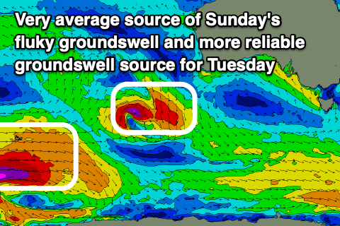
A long-period signal showing on Sunday hasn’t got any size to it, with it generated by a poorly structured low that’s currently west-southwest of Western Australia.
This will generate a possibly 1-2ft wave on the Surf Coast and 3ft+ to the east, with the models incorrectly combining swells and over-forecasting the size.
Local winds look favourable all day Sunday and N-N/NE, with the exposed beaches being the pick, while Monday may see a window of early light N winds ahead of a trough and SW change. A new, long-period W/SW groundswell is due to build through the day, but early ahead of the change will likely only be small.
This swell is being generated by a strong polar low that’s formed south-east of South Africa, with a great fetch of severe-gale to storm-force W’ly winds due to project east today, weakening a little while projecting slightly east-northeast tomorrow.
A moderate sized swell is due later Monday but more so Tuesday with 3ft+ waves on the Surf Coast, 5-6ft to the east but with poor, strong S/SE winds in the wake of Monday’s change. Winds are due to ease a little through the day before freshening later.
Winds look to remain out of the E/SE as the swell eases Wednesday, possibly lingering later week. With this in mind make the most of the weekend’s waves.
Comments
Every long weekend hahaha.