Workable winds for the coming period with fun swells

Victorian forecast by Craig Brokensha (issued Wednesday January 29th)
Best Days: Tomorrow morning Surf Coast, beaches Saturday morning, Sunday, Monday beaches, Tuesday beaches
Features of the Forecast (tl;dr)
- Easing swell tomorrow and Fri with light-mod S winds tomorrow (variable for a period to the west in the AM), freshening into the PM
- Light-mod S winds Fri AM, variable at times, freshening into the PM
- Small-mod sized mix of SW groundswell and mid-period W/SW swell building Sat, peaking in the PM, easing Sun
- Light E/SE tending NE winds Sat ahead of sea breezes
- Light, local offshore winds Sun, tending N/NE-N through the morning and variable into the PM
- Small-mod sized SW groundswell Mon with NE tending SE winds
- Easing swell Tue with variable offshore tending N/NW winds ahead of a late S/SW change
Recap
There was a small window of light W/SW winds early across the Surf Coast yesterday with an easing 2ft+ of swell, though conditions deteriorated through the morning as winds shifted back SW and strengthened. Everywhere else was poor.
Today we’ve got some new mid-period swell in the water with a moderate to fresh southerly wind that’s creating average but workable conditions for the keen on the Surf Coast with waves to 3ft+.
This week and weekend (Jan 30 - Feb 2)
The mid-period SW swell seen into today will hold well into tomorrow morning across the state thanks to the swell generating source being drawn out in nature yesterday.
Easing surf from 3ft is due on the Surf Coast and 4-5ft to the east but with lingering S winds that will likely tend variable for a period to the west through the morning.
This should provide decent enough conditions for a paddle on the Surf Coast with average surf continuing to the east.
Friday looks smaller along with similar, weak S’ly winds that will likely be variable at times across selected locations during the morning.
From the weekend we should start to see conditions improve across the beaches as high pressure moves in from the west, swinging winds from E/SE to light NE through the morning Saturday across locations east of Melbourne.
It’ll be lumpy but improving with an inconsistent SW groundswell due to be in the water, followed by some additional, slightly more consistent mid-period W/SW swell for the afternoon and Sunday morning.
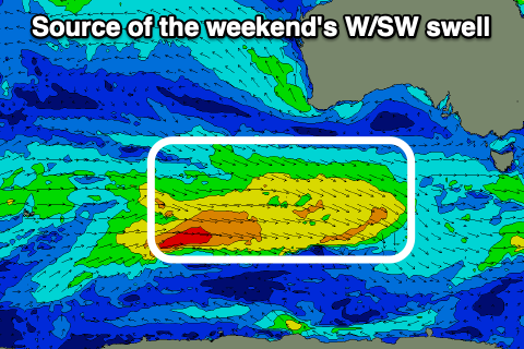
As touched on in Monday’s notes, a strong but distant low will generate Saturday morning’s swell, with slow 2ft+ sets expected on the Surf Coast magnets, 4ft+ to the east, while the mid-period energy will be generated by a now, weaker frontal progression that’s currently to our south-west.
This progression has been downgraded a touch and with that the size only looks to reach 2-3ft on the Surf Coast and 4-5ft to the east Saturday afternoon, backing off from a similar if not slightly smaller size Sunday morning.
Conditions will be better for all locations Sunday with light, local offshore breezes, increasing from the N-N/NE through the morning, tending more variable through the afternoon.
Monday also looks the goods with a light NE offshore to the east, variable to the west along with a new pulse of slightly stronger SW groundswell.

A strengthening low drifting unfavourably south-east under the country on the weekend will generate a quick burst of W’ly gales through our swell window. The off axis trajectory isn’t ideal but we should still see a fun kick in energy to 2-3ft on the Surf Coast and 4-5ft to the east and sea breezes only look relatively weak as well.
Tuesday will be smaller as the swell eases but clean again with local offshore winds, tending more N/NW into the afternoon ahead of a strong evening S/SW change.
This change should be followed by some new mid-period swell Wednesday then some distant groundswell Thursday but we’ll review this Friday.
Comments
Monday looks okay and the school holidays crowds will not be there . :-).
School holiday crowds, maybe not. Heatwave crowds, yes.