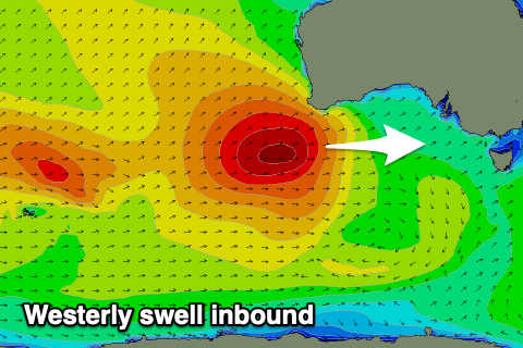
Good west swell inbound, cleanest as it eases
Victorian Forecast by Craig Brokensha (issued Monday December 16th)
Best Days: Thursday and Friday mornings to the east
Features of the Forecast (tl;dr)
- W/NW tending stronger W/SW-SW winds tomorrow with a building W/SW swell into the PM
- Moderate + sized W/SW groundswell for Wed with fresh S'ly winds
- Easing swell Thu with E tending fresh S/SE winds
- Smaller Fri with fresh E/NE-NE winds, easing ahead of sea breezes
- Small, inconsistent W/SW groundswell for Fri PM
- Strong S/SW winds Sat, slightly weaker but persisting Sun with small-mod levels of swell
Recap
The weekend saw a slow easing trend in mid-period SW swell, generated by weaker frontal activity on the back of the strong low that brought Thursday/Friday’s swell.
The Surf Coast eased back from the 3ft range with 4ft+ sets to the east on Saturday, smaller and to 2ft+ and 3ft+ respectively yesterday with favourable morning winds.
Today the surf has eased further and winds are strengthening out of the north ahead of an approaching trough and evening SW change.
This week and weekend (Dec 17 - 22)
The coming week revolves around a moderate + sized westerly swell due into Wednesday and Thursday across the state, with later today’s change linked to the frontal progression bringing the swell.
The swell will be very west in nature, generated by a great, slow moving low that formed to the south-west of Western Australia over the weekend.
Fetches of mostly gales, with slightly stronger embedded core winds have generated a large swell for Western Australia today that will lose size while moving through the Bight and come in smaller and slower again once diffracting and retracting into Bass Strait.
The remnants of the swell generating front is now moving in from the west and will bring a small increase in mid-period W/SW swell through tomorrow afternoon but with strong W/SW tending SW winds. In the morning when conditions look cleaner under a W/NW breeze, it looks to be tiny on the Surf Coast.

The groundswell will fill in Wednesday and should reach 4ft on the Surf Coast magnets with 6ft to occasionally 8ft sets on the beaches to the east but winds will be fresh out of the S’th as high pressure moves in behind tomorrow afternoon’s change.
The easing trend looks gradual into Thursday and winds will ease and tend E’ly during the morning to the east along with solid, easing sets from 5-6ft with 3ft+ waves on the Surf Coast.
Friday looks the best with a fresher E/NE-NE breeze, easing through the morning ahead of sea breezes. Swell wise, Wednesday’s energy will continue to ease while a new, long-range groundswell is due into the afternoon, generated by a distant storm that’s currently north of the Heard Island region.
The Surf Coast looks to be 2ft+ or so, mixed in with some south-east windsell while the Mornington Peninsula looks to come in around 3ft to occasionally 4ft.
Make the most of these windows of cleaner conditions on the beaches as a trough looks to bring a strong S/SW change on Saturday that will linger into Sunday, writing off the weekend.
Longer term, we’ve got some decent swell on the cards for next week with what looks to be favourable morning winds, but let’s have another look at this on Wednesday.

