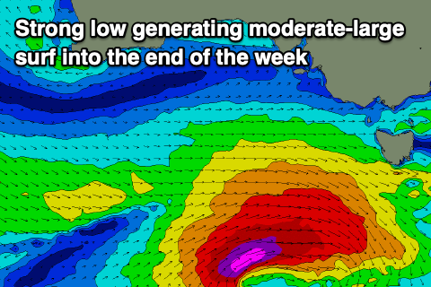
Upgrade in swell for the end of the week
Victorian Forecast by Craig Brokensha (issued Wednesday December 11th)
Best Days: Tomorrow, Friday morning, Saturday morning to the east
Features of the Forecast (tl;dr)
- Mod-large SW-S/SW groundswell building tomorrow afternoon/evening, peaking overnight and easing steadily Fri
- Moderate W/NW winds tomorrow, shifting W/SW into the PM and then fresher towards the evening from the S/SW
- NW tending W/NW winds Fri ahead of strong S/SW winds from late AM
- Easing swell Sat with E/NE tending fres SE winds
- Smaller Sun with fresh SE winds
- Strengthening N/NE tending N winds ahead of a late SW change Mon with small surf
- Moderate sized mix of W/SW swells building Tue but strongest Wed/Thu with winds unknown
Recap
The size held well into yesterday across the region with 3ft to occasionally 4ft waves across the Surf Coast magnets, 5-6ft to the east, while today we’ve got a little less size to 2-3ft to the west and 4-5ft to the east.
A long-range, inconsistent W/SW groundswell is due into the afternoon to a similar size but with a shift in winds to the S/SW, not overly strong to the west but gusty to the east.
This week and weekend (Dec 12 - 15)
The coming period is active with more west in the wind than usual thanks to a negative Southern Annular Mode event, lifting the westerly storm track further north than normal.
Keeping this in mind, the strong pulse of SW-S/SW groundswell for tomorrow afternoon and Friday is on track, with a deepening low currently forming south-west of us. The strength ofthe low has been upgraded further with fetches of severe-gales moving through our south-western and southern swell windows, generating a moderate to large spike of swell for later tomorrow, easing steadily through Friday.
The Surf Coast looks to build from 2-3ft tomorrow morning to 5-6ft later in the day (8ft to the east), easing back from the 4ft range on Friday morning, smaller and to 2-3ft on Saturday.
Local winds will continue to favour protected spots with a good W/NW breeze tomorrow morning, only tending W/SW into the afternoon and without much strength ahead of more onshore, fresher breezes later.

Friday morning looks great with a dawn NW breeze, shifting W/NW through the morning ahead of a strong S/SW breeze developing from late morning.
Come Saturday, winds are now looking better for the beaches to the east with a variable E/NE breeze and easing surf from 4ft+ or so, but get in ahead of afternoon SE breezes.
Sunday still looks average with a fresh SE’ly and further drop in swell.
Into next week, we’ve got small to tiny levels of swell ahead of a good new W/SW swell through the middle of the week.
This will be generated by a healthy mid-latitude frontal system projecting up and under Western Australia over the weekend, moving further under the country and towards us early next week.
We should see moderate levels of swell from Wednesday through Thursday but a high moving in from the west will see winds go onshore Wednesday, likely improving Thursday. More on this Friday.

