Improving conditions on the beaches with a bit of size

Victorian Forecast by Craig Brokensha (issued Wednesday November 20th)
Best Days: Beaches early tomorrow and Friday, Saturday both regions, Monday morning both regions
Features of the Forecast (tl;dr)
- Moderate sized, inconsistent SW groundswell building tomorrow, peaking into the PM, easing Fri
- NE-N/NE tending S/SE winds (PM) tomorrow
- N/NE tending fresh SE winds (mid-PM) Fri
- Small-mod sized S/SW swell for Sat with fresh N/NE winds to the east, lighter N/NW to the west, easing ahead of a late afternoon S change
- Easing swell Sun with variable winds ahead of sea breezes
- Small-mod sized mid-period SW swell Mon with variable winds ahead of a late S change
- Onshore S winds Tue through Thu
Recap
Lingering onshore winds in the wake of a trough earlier in the week have created bumpy conditions the last two mornings, though it’s been doable across most regions with moderate levels of swell.
This week and weekend (Nov 21 - Dec 1)
Conditions are finally set to improve across the beaches from tomorrow as high pressure moves in from the west, allowing winds to swing offshore.
As Ben touched on earlier in the week, we’ve got a strong but inconsistent pulse of SW groundswell due to fill in through tomorrow and early looks the go before it likely overpowers things into the afternoon when it peaks.
The source was a strong polar low to the south-west of Western Australia and we’re expecting the Surf Coast to build from an inconsistent 2-3ft in the morning to 3-4ft through the afternoon with 3-5ft surf to the east, building to 5-6ft into the afternoon.
Morning E/NE-NE winds will favour locations to the east ahead of fresh S/SE sea breezes while Friday looks the goods as well with a N/NE offshore holding until early afternoon before fresh SE breezes kick in.
Size wise the swell should start fading Friday with easing 3ft+ sets on the Surf Coast and 4-5ft+ waves to the east.
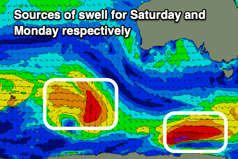
Moving into the weekend, we’ve got a decent pulse of mid-period S/SW swell on the cards for Saturday now, generated by a south-east tracking low that will intensify while moving closer towards Tasmania tomorrow. This is late in our swell window but regardless this should maintain 3ft sets on the Surf Coast magnets on Saturday, 4-5ft to the east before easing into Sunday from 2ft+ and 4ft respectively west and east of Melbourne.
Winds on Saturday will freshen and be locally offshore out of the N/NE to the east and N/NW to the west ahead of a trough, with winds due to ease through the day ahead of a late afternoon, gusty S’ly change.
The change will weaken overnight leaving variable winds into Sunday morning but there’ll likely be lots of lump and it won’t be as lined up as the day before.
Looking at next week, and another south-east tracking low looks to generate a small to moderate sized increase in mid-period SW swell on Monday as variable morning winds favour both coasts, while a trough followed by high pressure later in the day looks to bring onshore winds from Tuesday through Thursday.
Longer term it looks like a strong polar low firing up to the south-west of Western Australia will bring a moderate sized pulse of SW groundswell next weekend, more on this Friday.
Comments
Too big and overpowering? Ha ha. This is a piss take yeah?
Bita respect to craigos waz
Welcome back Craig! It’s been lonely without you ️
*sniffle
You said you'd call.
Strange comment, seeing you can't access the notes.
waz take it easy calabrese, bit of respect for these glorious lord craigos notes
Wazh your mouth out Waz! Be straight to Hades with that kind of blasphemy!
Monday morning at W.P. was half decent until the wind changed.I am watching for another chance to surf those rock reefs.