Mixed swell pulses and winds
Victorian Forecast by Craig Brokensha (issued Monday October 21st)
Best Days: Today to the east, tomorrow morning, Wednesday morning Surf Coast, Thursday morning Surf Coast, weekend on the beaches
Features of the Forecast (tl;dr)
- Small-mod sized W/SW swell for this afternoon, easing tomorrow
- N/NE winds tomorrow AM (N/NW in pockets to the west), tending sea breezy ahead of a late, strong S/SW change
- Moderate sized S/SW groundswell Wed with W/NW tending SW-S/SW winds late AM
- Small-mod sized mid-period W/SW swell Thu with fresh W/NW tending strong SW winds
- Reinforcing SW swell Fri with fresh SW-S winds (possibly weak W early)
- Easing swell Sat with E/NE-NE tending SE winds
Recap
The weekend was poor following Friday afternoon’s change, with strong onshore winds kicking up a weak windswell Saturday, which then faded Sunday.
Today we’ve got some new mid-period W/SW swell in the water with a slightly stronger increase due into the afternoon.
Conditions are better to the east but still not great, with winds due to continue to improve and tend variable as a low off the East Coast slowly weakens.
This week and weekend (Oct 22 - 27)
Today’s improving conditions are thanks to the low off the East Coast weakening before being pushed off to the east ahead of the next swell generating system moving in from the west.
This will bring N/NE winds tomorrow morning with pockets of N/NW winds across the Surf Coast, giving into weak sea breezes ahead of a late afternoon, strong S/SW change.
Swell wise, the energy due into this afternoon (generated by a healthy progression of frontal systems to the south-west of Western Australia last week) is due to start easing tomorrow, with the Surf Coast offering 2-3ft sets while the Mornington Peninsula comes in at 4-5ft.

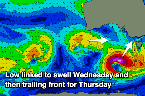
Tomorrow afternoon’s change will shed off a strong low forming south-west of us today, with it deepening rapidly into this evening and tomorrow.
With this, a fetch of severe-gale to possibly storm-force W-W/NW winds will be generated through our southern swell window, producing a moderate sized pulse of S/SW groundswell that’s due to fill in Wednesday morning.
The size is a little tricky owing to the late formation and majority of the fetch being aimed more south-east but we should see a good kick to the 3ft+ range on the Surf Coast with 4-5ft sets to the east and with light W/SW-SW winds that will tend W/NW locally across the Surf Coast.
The models aren't picking this swell up well at all.
This easing of local winds will be thanks to the next swell generating front moving in from the west, but it looks mostly weak in nature, followed by a secondary system into the evening and Friday.
Small to moderate levels of mid-period swell are due from these sources, W/SW in nature on Thursday and to 2-3ft on the Surf Coast with 4-5ft sets to the east, more SW on Friday morning and a similar size.
A fresh W/NW breeze will favour the Surf Coast Thursday morning ahead of a late morning, SW change, while Friday looks dicey with SW tending S winds that might be lighter W’ly at dawn. Not great.

The weekend looks to favour the exposed beaches as winds shift back to the north-east along with small, easing levels of swell from Friday. Sunday looks small again as the swell increases a little out of the W/SW, but check back here on Wednesday for an update on this.
Longer term, a stream of healthy frontal activity moving in under the country from late week through the weekend looks to generate fun levels of W/SW swell with west winds for early-mid next week. More on this Wednesday.

