Plenty of swell activity inbound but with tricky winds
Victorian Forecast by Craig Brokensha (issued Wednesday October 9th)
Best Days: Friday morning Surf Coast for the keen, Sunday, Monday morning to the east, Tuesday and Wednesday to the east
Features of the Forecast (tl;dr)
- Tiny surf tomorrow with strong N tending NW then W/SW winds late AM, SW into the PM
- Late increase in W/SW swell tomorrow, further Fri with a stronger groundswell into the PM
- W/NW winds Fri AM, shifting strong SW into the PM
- Moderate + sized mix of groundswells Sat with moderate S/SE winds, freshening into the PM
- Easing surf Sun with mod-fresh N/NE winds, possibly tending E/NE-NE into the PM
- Smaller Mon with E tending strong SE winds
- Localised SE windswell Tuesday along with a moderate sized S/SW groundswell with E/NE winds
Recap
Following Monday’s change, conditions remained poor into yesterday along with slowly easing levels of swell, a little smaller again today.
Winds are better for the beaches this morning but not strong enough to iron out overnight lump and bump for the dawny. It’s improving as we speak though with an unfavourable dropping tide. Sea breezes will kick in this afternoon as the swell fades further.
This week and next (Oct 10 - 18)
Tomorrow looks to still be a lay day as the current swell continues to fade with early strong N tending NW then W/SW winds late morning, SW into the afternoon.
This will be as a healthy swell generating front moves through, with some close-range W/SW swell to follow into the late afternoon/Friday morning.

There should be some less consistent but stronger W/SW groundswell filling in under this localised energy on Friday, building through the afternoon ahead of a secondary stronger, better pulse of energy for Saturday.
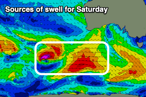
Friday’s swell was generated by the earlier stages of the frontal progression which formed in the southern Indian Ocean, while Saturday’s energy is still being generated by secondary, more favourably aligned fetches of strong to gale-force W/SW winds to the south of Western Australia last night and today.
Size wise the first swell on Friday should build from 2ft to occasionally 3ft in the morning to 3-4ft into the late afternoon but with a W/NW breeze, shifting strong SW early afternoon.
Saturday will see the better swell fill in, along with a further pulse generated by a tight little front racing in on the backside of the system currently south of Western Australia. The Surf Coast should come in at 4-5ft with 6ft to possibly 8ft sets to the east but with moderate S/SE winds lingering from Friday afternoon’s change. These winds now look a touch stronger than expected on Monday and not great.
Sunday looks the best with a N/NE offshore that should last most of the day, if not tending more E/NE-NE into the afternoon along with easing levels of swell from 3-4ft on the Surf Coast and 6ft to the east.

Moving into next week and the winds on Monday are a little tricky thanks to a trough moving through the region and possibly forming into a low off the southern NSW coast.
It looks like E’ly winds will strengthen kicking up some localised later Monday and into Tuesday, along with the arrival of a moderate sized S/SW groundswell generated by a low forming south-west of Tasmania on Sunday. Winds should shift more E/NE Tuesday morning and NE Wednesday but we'll have to review this.
Beyond this, a very long-period W/SW groundswell from the Indian Ocean is due later Wednesday but more so Thursday as winds tip more NE on the former, possibly S/SW on the latter. We’ll have a closer look at this on Friday as the models diverge a little with the low in the region.

