Shifty period of swells and winds
Victorian Forecast by Craig Brokensha (issued Monday October 7th)
Best Days: This morning Surf Coast, Wednesday morning exposed beaches, Saturday, Sunday
Features of the Forecast (tl;dr)
- Mix of W/SW swells today, easing a touch tomorrow and then fading Wed
- Fresh S tending weaker S/SE winds tomorrow
- Light E/NE-NE tending fresh E/SE-SE winds Wed
- Strong N/NW tending SW winds Thu with some building windswell to follow
- Mix of mid-period W/SW swell Fri AM and building moderate + sized groundswell later, peaking Sat
- W/NW tending strong SW winds late AM Fri, light S-S/SE on Sat
- N/NE-NE tending SE winds Sun with moderate sized levels of easing W/SW swell
Recap
A generally average weekend of surf with no size on Saturday, while yesterday a small lift in westerly swell took it’s time to get going. The morning was small to tiny with the late afternoon/evening kicking to a bumpy 2ft to occasionally 3ft across the Surf Coast magnets.
This morning we’ve got more consistent surf in that 3ft range on the Surf Coast magnets under a better offshore wind. Winds will shift strong W/SW and then SW into the afternoon so make the most of this morning.
This week and weekend (Oct 8 - 13)
Today’s change will be linked to a final frontal system clipping us today, followed by high pressure which will see winds lingering out of the S’th tomorrow, fresh in nature. They are due to ease and tend more S/SE but the damage will be done.
Swell wise, a reinforcing pulse of W/SW energy is due to a similar size, easing from 3ft on the Surf Coast, 4-5ft to the east while a smaller pulse of S/SW energy on Wednesday looks to be very minimal at best.
The Surf Coast looks to ease back from 2ft with 3ft to possibly 4ft sets to the east but with better E/NE-NE offshores for the beaches before sea breezes kick in.
Make the most of this window as Thursday will become tiny as winds strengthen from the N/NW ahead of a SW change around midday.
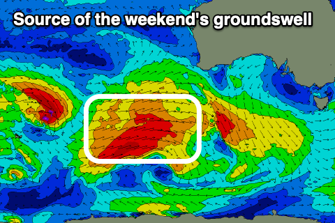
This change will be associated with the remnants of a strong frontal system moving in from the southern Indian Ocean, with it kicking up some low quality windswell later in the day and more so Friday, while the stronger levels of distant W/SW groundswell fill in for the afternoon/Saturday.

The groundswell component will be generated by gale-force fetches moving through our distant western swell window and then slightly better aligned activity to the south-west of Western Australia today and tomorrow.
The distant energy isn’t great with the mix of localised energy likely to come in around 2-3ft on the Surf Coast Friday morning with 4-5ft sets to the east. The better swell from under Western Australia is then due later in the day but more so Saturday with surf in the 5ft range due on the Surf Coast and 6ft to possibly 8ft sets to the east.
The remnants of this swell generating front will also move through on Friday afternoon/Saturday, bringing with it some moderate sized mid-period swell to the mix. Unfortunately winds will swing strong SW on Friday following a morning W/NW breeze, with Saturday seeing lighter, lingering S winds when the swell peaks offeing decent enough conditions in the morning for a paddle.
Sunday should become cleaner as winds shift back around to the N/NE-NE during the morning and the swell starts to ease back from the 4ft range on the Surf Coast, 6ft or so to the east.
Into next week, the outlook is a little unknown wind and swell wise so check back here on Wednesday for a clearer idea.

