Funky few days ahead, improving again from next week

Victorian Forecast by Craig Brokensha (issued Wednesday September 11th)
Best Days: This morning, Monday morning, Tuesday morning, Wednesday
Features of the Forecast (tl;dr)
- Fresh S tending S/SW winds tomorrow with a localised windswell
- Moderate + sized W/SW groundswell building Fri PM, peaking Sat with W/NW tending fresh SW winds Fri, strong S Sat (possibly weaker S/SW at dawn)
- Easing surf with mod-fresh S/SE winds Sun
- W/NW tending SW winds Mon
- Moderate sized mix of swells Tue with W/NW tending SW winds
- Easing surf Wed with NW winds
- Larger surf from late next week
Recap
Our less consistent W/SW swell provided good 3-4ft waves most of yesterday across the Surf Coast, workable in selected spots to the east. This morning the swell is slowly easing but with cleaner conditions across most spots before an onshore change moves in during the day.
This week and next (Sep 12 - 20)
All good things must come to an end, for now.
Our run of good to great to excellent waves on the Surf Coast is drawing to a temporary end, with troughy weather due to dominate in the wake of a strong S/SW change this afternoon.
This will be thanks to the recent run of frontal activity becoming subdued as high pressure and troughs clip the state.
Following this afternoon’s change, winds will abate but remain fresh from the S’th tomorrow, shifting S/SW into the afternoon with a mix of localised windswell and background W/SW swell energy.
Winds should tip back to the W/NW on Friday morning but swell wise, the mix of energy from tomorrow will be on the decline and lucky to be 2ft to occasionally 3ft on the Surf Coast, bumpier and bigger to the east.
Later in the day but more so Saturday, we should see a moderate + sized W/SW-SW groundswell filling in, with a strong, broad low currently to the south-west of Western Australia being the source.
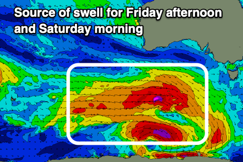
The low will be a little disjointed regarding fetch generation, with prefrontal gale to severe-gale NW tending W/NW winds due to then be followed by gale to severe-gale W’ly winds, moving more into our south-western swell window while weakening tomorrow.
There’ll also be storm-force W/NW winds at the base of the low, though very small in scope and not aimed well at all.
Overall the strength of the system has been upgraded a little, with building sets towards 4ft later Friday on the Surf Coast as winds shift W/SW-SW, peaking Saturday morning to 4-5ft, with 6-8ft sets to the east.
Unfortunately conditions are still looking poor for this swell as a high moves in from the west, bringing strong S’ly winds, possibly weaker and S/SW at dawn Saturday. Sunday will then see fresh S/SE winds, easing through the day as the swell eases.
Monday morning looks better as winds tip back to the W/NW along with a mix of swells back to the 3ft across the Surf Coast.
Now, into Tuesday, a good pulse of SW groundswell is due, generated by a polar fetch of severe-gale W/NW winds sliding under the country Friday and Saturday.

Size wise, it looks to be moderate in size, while secondary frontal activity moving under the state early next week should produce some additional close-range energy on top for the afternoon and Wednesday morning.
Sizes are a little tricky to nail down but we should see waves to 4ft on the Surf Coast, 6ft+ to the east along with morning W/NW winds, shifting SW into the afternoon Tuesday, NW on Wednesday.
Longer term we’ve got a re-strengthening of the westerly storm track south of the country mid-late next week, generating another good run of moderate to large surf from late week. More on this Friday.
Comments
Sending out karma to the guy that rescued my board yesterday at Centreside after my leggy string untied itself