Good waves enroute for next week

Victorian Surf Forecast by Ben Matson (issued Wednesday July 17th)
Features of the Forecast (tl;dr)
- Poor surf Thursday
- Small clean surf west of Melbourne Friday
- Average waves Saturday
- Some potential for Sunday west of Melbourne, though likely small in size
- Solid W/SW swell for Monday with Surf Coast looking best
- Plenty of swell and NW winds favouring the Surf Coast for the rest of next week
Recap
Onshore winds have created poor surf across most coasts over the last two days, however Phillip Island was a small outlier, with lighter winds tending SE allowing for clean faces throughout parts of Monday and Tuesday mornings. Elsewhere it’s been a terrible mess with short period S/SW swells and gusty southerly winds associated with a deep low near Tasmania.
This week (Jul 18 - 19)
No major changes to the outlook for the rest of the week.
Onshore winds have eased back across the Victorian coast, but this is only a temporary fixture, with SW winds expected to restrengthen overnight as a new low intensifies off Tasmania’s East Coast. They’ll ease through the day but the damage will be done by the morning, and even if we see a brief locally induced W’ly flow along the Surf Coast at dawn on Thursday, the overnight onshore breeze will have left the ocean in a rough state for the early session.
As for surf, there’ll be some short period swell from the overnight airstream, plus some underlying long range groundswell (sourced from below Heard Island over the weekend) that will build towards a peak Thursday afternoon; size from both sources likely to be around the 2-3ft mark. Keep your expectations low for any quality.
East of Melbourne will be bigger (3-5ft) but equally poor on the surface with no chance of a morning pocket of favourable winds.
Friday will then see much better conditions as winds swing to the N/NW and freshen, however Thursday’s swell will have peaked overnight and will be trending down. Consider yourself lucky if you find any leftover 2-3ft sets as it’ll be down to 2ft or less by lunchtime and smaller into the afternoon.
These winds may offer a short period of OK conditions at select beaches east of Melbourne, but it’s a dicey call and won’t last long even if it does eventuate (it’s a low confidence event).
This weekend (Jul 20 - 21)
I’m still not expecting anything of great interest this weekend.
The wave models have perked up in the last 24 hours with some windy surf potential for Saturday, but it’s all short range W’ly energy trailing a frontal passage that’ll sweep across Bass Strait overnight Friday.
Yes, there is a significant frontal progression pushing through the Southern Ocean later this week, but most of the swell they are generating won’t arrive until early next week - and with windy conditions both days (Saturday from the west, Sunday from the north-west), there won’t be any rideable options east of Melbourne.
As such, with the Surf Coast your only option, I’m expecting average surf to build on Saturday - accompanied by gusty westerlies - building to 1-2ft at most breaks, maybe some 2-3ft sets at the regional swell magnets.
Sunday is a different story, as winds will straighten up from the NW providing clean conditions across the reefs, and a better quality groundswell will build across the region. However it will also be very westerly in direction and is likely to fall below a decent size threshold. Best estimates right now are inconsistent 2ft sets in the morning, building to an equally inconsistent 3ft in the afternoon at the swell magnets (smaller elsewhere), but I wouldn’t plan any highway miles right now - it’s another low confidence event.
Next week (Jul 22 onwards)
So, the storm track for the end of this week and weekend looks very impressive on the synoptic charts, but once you analyse the surface wind field, it starts to fall apart at the seams, just a little bit (see below).
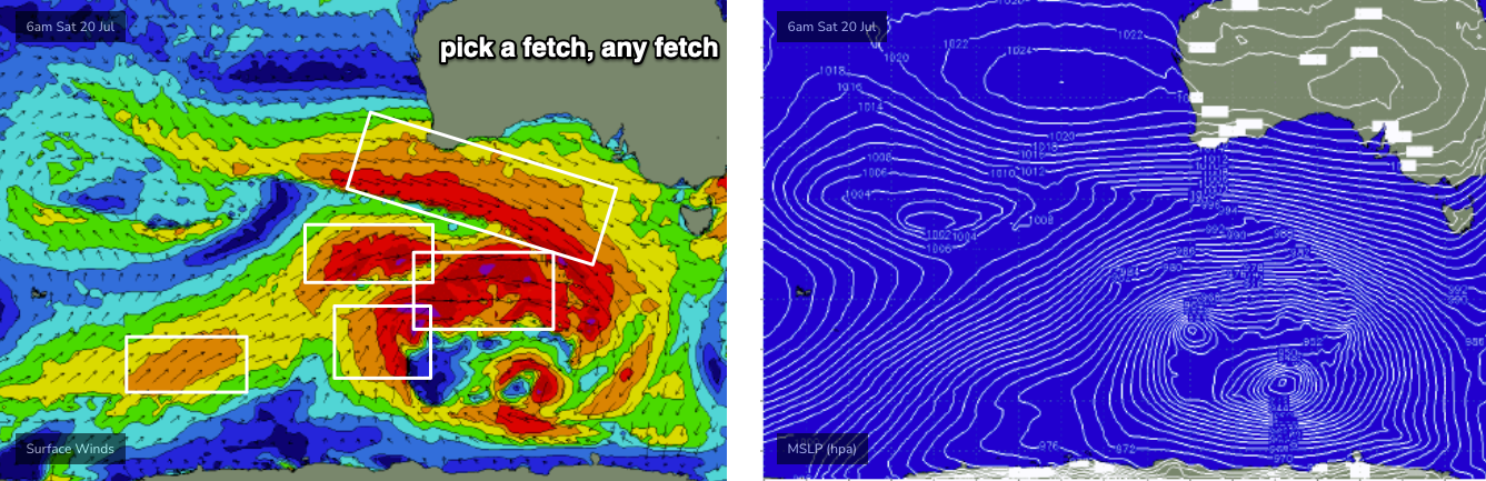
Whilst the greater swell window will be active under some kind of reasonably-aligned fetch, wind strengths won’t be continuous across the basin - with patchy regions of gales intermixed with regions of differently aligned fetches, of lesser strength.
This doesn’t mean we won’t see good waves, but it is one of several factors that’ll work against us next week. This is because the most likely outcome will be an ocean with multiple swell trains from approximately the same direction (W/SW) displaying different sizes, periods and directional spreads. The broader concept of which is actually quite beneficial for beachbreaks in NSW and Qld, but not ideal for Victorian reefbreaks, which are designed to respond best to singular long period swell events.
So now that I have sufficiently lowered your expectations, allow me to boost it back up again, with a favourable wind forecast for Monday, as post-frontal W/SW winds (overnight Sunday) swing to a light morning NW breeze. This should create generally clean conditions.
The predominant swell W/SW direction will will cap wave heights probably around the 3-4ft mark in Torquay, though the swell magnet reefs may punch a little higher at times (5-6ft) - but overlapping swell trains will create mixed results in the actual surf department.
A slight easing is expected into Tuesday though the good news from there through until Friday is that (1) winds will probably remain offshore along the Surf Coast for most of the week, and (2) wave heights should ebb and flow in the 3-4ft range (give or take) most days.
East of Melbourne looks tricky wind wise next week, as there may not be quite enough size for Western Port (Monday being an exception), and everywhere else may largely become blown out. I’ll fine tune the specifics in Friday’s notes.
Long term has a whole stack of swell on the way as the storm track resumes normal winter programming. So, there’s plenty to look forward too.
See you Friday.
Comments
Must be a late Friday from ol' Thermal
The later the forey, the closer it is to the next swell and therefore the more accurate it will be, at least that's what I'm telling myself haha