Average period ahead, next week looks better

Victorian Surf Forecast by Ben Matson (issued Monday July 15th)
Features of the Forecast (tl;dr)
- Poor surf for much of this week
- Average weekend, best options west of Melbourne on Sunday
- Next week looking better with building swells and NW winds
- Second half of next week shaping up for better size prospects
Recap
Saturday offered great waves west of Torquay with morning offshore winds, and relatively modest afternoon onshore, as surf size built into the 4-6ft range by the afternoon (smaller earlier). East of Melbourne was bigger with good waves at sheltered spots. Sunday and Monday delivered average tending poor surf at most spots thanks to tricky winds (mainly onshore) associated with a developing low east of Tasmania, and associated local windswells that have built in size today.
This week (Jul 16 - 19)
Look, it’s a super complex synoptic chart, and initial indications are to write off the next three days thanks to gusty onshore winds.
But it’s not as simple as that.
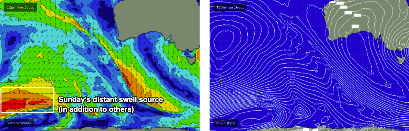
Groundswell potential is low for the short term, as the the recent trough block across the Tasman Sea has also resulted in a ridge of high pressure south of the the continent, stalling eastward-moving frontal systems in the Southern Indian Ocean (i.e. Victoria’s swell window). We’ve got some long range W/SW groundswell due around Thursday, sourced from weekend activity in and around Heard Island longitudes, but there won’t be much size and local winds look iffy.
Prior to then, Tuesday and Wednesday will largely be dominated by fresh southerly winds thanks to the low east of Tasmania - however, there is a chance for small additional areas of low pressure to develop within Bass Strait during this period, which could temporarily influence local winds. Chance for good waves are externally low through this period, but it’ll be worth an occasional glance at your nearest weather station to see whether there are any unusual signals, as this could offer brief windows of peaky beachies. However, most of the surf is locally generated so quality will be at a minimum.
Thursday will see this local pattern abating and clearing to the east, but Friday is the next best chance for clean conditions as pre-frontal N/NW winds strength across the coast.
The long range W/SW swell due Thursday will be easing by this time so I’m doubtful that we’ll see much more than an inconsistent 2ft west of Melbourne on Friday. Expect more size but potentially a more detrimental airstream east of Melbourne.
Long story short, don’t get your hopes up for surfing this week.
This weekend (Jul 20 - 21)
The weekend’s shaping up with a small degree of promise, but not much.
A weakening front will clip the state overnight Friday, swinging winds around to the west but they’ll probably resume a W/NW flow throughout Saturday. Small leftover surf will accompany a minor increase in mid-range W’ly swells that won’t show very well west of Melbourne, and will be too wind affected east of Melbourne.
So, in general you can forget Saturday.
Sunday has more promise with approaching fronts in the Bight expected to freshen NW winds across the coast, as a series of W/SW swells fill into Bass Strait, generated by broad but largely unconsolidated frontal activity south of the continent later this week.
I feat that there will probably be too much west in the swell direction to favour the Surf Coast - though the early polar stages of this pattern (tomorrow, south of Heard Island, see below) should allow for some small waves to show in Torquay, probably somewhere in the 2ft range, maybe 2-3ft into the afternoon. Keep your expectations very low.
Next week (Jul 22 onwards)
The long term looks more typical for Victoria wind-wise, with an amplifying long wave trough west of the state maintaining moderate to fresh NW winds for much of the week.
The broad storm activity mentioned above (for Sunday) will push a little more convincingly into our swell window so Monday thru’ Wednesday is looking fun with clean 2-3ft surf across the Torquay stretch, whilst the second half of the week is on target for a bigger round of surf as the storm track becomes more defined south of the continent.
As such, pencil in the second half of next week and the following weekend for a return to more typical winter surf conditions.
See you Wednesday!
Comments
haha, love it, sums it all up : " it’s a super complex synoptic chart," , and goes on to say " But it’s not as simple as that"....I'm prepped to wait a week if need be.
Not a great outlook for the Bells longboard classic this week. I'm sure they will make it look better than it is.
Looking like it will be offshore for them at least bit different to last years.
Yeah, clean little runners at Rincon, even 2 or maybe 3ft has got to be better than strong onshore or flat which has been most of winter so far. The good days are few and far between on the Surf Coast.
Winter blast, Melbourne hit, lots of precipitation in the east:
Polar blast to come, east coast cold & snow event might see snow in QLD:
Cmon Benny give us the good news..
question is it takeing longer to do a writeup on a upgraded swell.....or cut and past job for 1-2ft tba
Jeez tough crowd! haha
Updated now: https://www.swellnet.com/reports/forecaster-notes/victoria/2024/07/17/go...
We’re at all time levels of bitter and twisted on the west coast down here Ben, please excuse us.