Good outlook from the weekend
Victorian Surf Forecast by Craig Brokensha (issued Wednesday July 3rd)
Best Days: Beaches to the east from mid-late morning tomorrow, Saturday, Sunday, Monday, Tuesday
Features of the Forecast (tl;dr)
- Inconsistent, moderate sized W/SW groundswell building slowly tomorow PM, peaking Fri AM
- Light E/NE-NE winds developing from Torquay east during tomorrow morning, E/SE-SE into the PM and strengthening
- Mod-fresh E/SE-SE winds Fri, tending lighter E during the morning across selected spots east of Melbourne
- Moderate + sized SW groundswell for later Fri, peaking Sat with N/NE winds developing across most locations east of Anglesea, with variable sea breezes
- Easing swell Sun with N/NE tending E/NE winds
- Moderate sized reinforcing S/SW groundswell Mon with N/NE tending NE winds
- Easing swell Tue with N/NE tending E winds
Recap
A tricky trough moved this way and that through yesterday with initially average conditions across all locations improving slightly as winds eases across the Mornington Peninsula with a fun amount of swell. Phillip Island saw variable winds all day and fun waves across the beaches, but today looks better across exposed breaks with a little less swell and generally clean conditions.

Decent surf this morning
This week and weekend (Jul 4 - 6)
The coming period will be dominated by the monster high sitting south-west of us, with it possibly breaking the record for the highest pressure registered in Australia over the coming days. I’ve discussed this and how the high pressure will influence our local tides in this article: Riding A July High
The high will have a huge effect on the local surf, with it blocking any major storms from firing up in our main swell window, but on the other hand, provide a great run for the exposed beaches as winds hold from the north-eastern quadrant.
This looks to kick in from the weekend, but before that, the shifting high pressure cell from west to east and east to west will bring tricky, varying winds.
Tomorrow morning looks to offer a period of E/NE-NE winds from Torquay to Phillip Island at some stage, likely not dawn and shifting back E/SE-SE around midday before strengthening into the late afternoon.
This will be along with an inconsistent, moderate sized W/SW groundswell that will be on the build, peaking Friday morning.
There should be a window before the swell gets too big for the beaches in the morning, with increasing size towards 3ft on the Surf Coast late, 4-5ft+ to the east.
Friday looks to come in at 3ft and 4-6ft west and east of Melbourne respectively, with what looks to be unfavourable E/SE-SE winds, ending lighter E’ly across selected spots east of Melbourne through the morning.
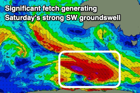
Now, into the late afternoon but more so Saturday, our stronger pulse of W/SW-SW groundswell is due, generated by the first of a series of south-east but strong tracking fronts down towards the polar shelf.

This first system looks the most significant with a great fetch of severe-gale W/NW winds being generated, producing a moderate + sized SW groundswell for Saturday to 4-5ft on the Surf Coast magnets, 6ft+ to the east.
Winds at this stage look to improve through the morning, tending light N/NE across most locations from Anglesea, east, with winds becoming variable into the afternoon. Conditions might not be perfect but it’s definitely worth pencilling in a surf or two.
Sunday looks good as well with N/NE offshores (E/NE into the afternoon) with easing levels of swell from 3ft to possibly 4ft on the Surf Coast, 5ft+ to the east.
Into Monday, another pulse of fun S/SW swell is due, generated by weaker but trailing frontal activity projecting towards the polar shelf, coming in 3ft on the Surf Coast and 4-5ft to the east under a N/NE tending NE winds.
The swell will then fade Tuesday with favourable winds again, tiny Wednesday with a shift in winds more to the west.
This will be as the high starts moving east and frontal activity begins edging in from the west, bringing some new energy later week and beyond. More on this Friday.


Comments
End of next week looks decent on the charts