Very average week ahead
Victorian Surf Forecast by Craig Brokensha (issued Monday June 3rd)
Best Days: Tomorrow afternoon Surf Coast for the keen, Monday next week
Features of the Forecast (tl;dr)
- Inconsistent, small to moderate sized W/SW groundswell building tomorrow, peaking later, easing Wednesday
- Moderate W/NW winds tomorrow, fresh S/SW Wed
- Easing swell Thu with E/SE-SE tending S/SE winds
- Small, inconsistent mix of swells building Fri, holding Sat, easing Sun
- Fresh S/SE winds Fri with W/NW winds Sat, SW Sun
- Small-moderate sized mid-period W/SW swell for Sun, easing Mon with N winds
Recap
Friday afternoon’s strong increase in swell eased back into Saturday with clean conditions on the Surf Coast and easing 4ft sets, larger to the east but bumpy.
A trough brought a shallow change into the afternoon, while yesterday was average with fresher S-S/SE winds and smaller levels of swell.
This morning conditions are small to tiny across the region as S’ly winds persist.
This week and weekend (Jun 4 - 9)
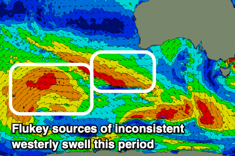
Looking at the period ahead and it’s a bit of a tricky one with less reliable, inconsistent W/SW swells with initially favourable winds for the Surf Coast tomorrow, then becoming flukey thanks to instability hanging around the region.
We’re in between swell generating systems with a strong low off the East Coast generating large surf for southern NSW, while over to the west, the Indian Ocean is delivering large swells for Western Australia and Indonesia.
We’re currently under the influence of the low to our east, bringing southerly winds, but a shift to the W/NW is due tomorrow along with the first pulse of long-range, inconsistent W/SW groundswell.

It was generated by a strong mid-latitude frontal progression to the west-southwest of Western Australia, with it due to build to an inconsistent 3ft on the Surf Coast magnets mid-late afternoon, 4-6ft to the east.
The swell is due to ease Wednesday and with it, winds are due to also shift S/SW, moderate in strength. There’s a very slim chance of early W winds around Torquay but the swell is not worth driving far for.
Into Thursday winds are due to shift E/SE-SE during the morning with a further drop in size, with fresher S/SE winds on the cards for Friday, both lay days.
A small, inconsistent mix of tricky W/SW swells are due into Friday afternoon and more so Saturday, but the sources aren’t as good as the next two days, with the Surf Coast coming in around 2ft or so, 4ft to the east.
Winds should shift back to the W/NW on Saturday ahead of a weak front, shifting SW on Sunday a new mid-period W/SW swell.
This will be generated by a small low forming under Western Australia late week. It will likely perk things up to 2-3ft on the Surf Coast and 4-5ft to the east Sunday, easing Monday with N winds.
Looking at next week and there’s no real improvement to the outlook with mid-latitude systems firing up new western Australia sitting too far north of our swell window. This makes for another lean run through next week.
More on this Wednesday.


Comments
It's been a lean May after a great run in April
Agh I forgot to mention the SE swell from the low moving through Bass Strait today. Looks great for selected spots.
oooooh
Yes noticed an extra foot or so of surf from mid afternoon and winds went west. More fun than I was expecting.
The conditions on the surf cameras on the M.P. and W.P. stretch looked rather shite this morning. I am glad I slept in and got some well needed rest.