Fun options over the coming days then poor from Sunday
Victorian Surf Forecast by Craig Brokensha (issued Wednesday May 27th)
Best Days: Today, tomorrow, Friday afternoon, Saturday morning
Features of the Forecast (tl;dr)
- Inconsistent W/SW groundswell easing tomorrow with strong N/NE winds, easing a touch later and tending more N on the Surf Coast
- Small Friday morning ahead of a moderate + sized pulse of close-range swell into the PM
- Strong N/NW tending W/NW winds
- Easing swell Sat with W/NW winds, tending S/SW late AM and then S'ly into the PM
- Fresh E/SE winds Sun with a building SE windswell and moderate sized mid-period S/SW swell
- Strong SE tending S/SE winds Mon with a moderate sized SE windswell
- Strong S/SW winds Tue, possibly easing and tending E/SE with a moderate sized, inconsistent W/SW groundswell on the build
Recap
Our first pulse of W’ly swell came in around forecast yesterday with clean conditions and 2-3ft sets on the Surf Coast magnets, with surf more to 4ft to the east.
Today, our less consistent and trickier long-period W/SW groundswell is filling in with slow but punchy sets to 3-4ft on the Surf Coast magnets, a little under the expected size, with 5-6ft sets to the east. Winds have a bit of north in them today and will remain so into the afternoon while strengthening to the east.
This week and weekend (May 30 - Jun 2)
Today’s inconsistent W/SW groundswell looks to peak through this afternoon and then ease back through tomorrow as winds become stronger out of the N/NE. We may see them easing into the afternoon/evening while tending more N across the Surf Coast but in short, the beaches will be the go.
Easing sets from 2-3ft are due on the Surf Coast magnets with 4-5ft sets to the east, smaller into Friday morning.
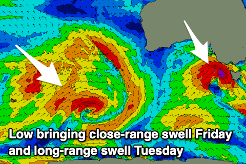
We then look at the mid-latitude forming in the Bight and pushing in and across us on Friday.
Most of it’s swell generating capabilities will be too far north of our swell window, but come Thursday evening, it’s due to drop further south and more into our swell window. This will be while generating a burst of strong to gale-force W/SW winds Friday morning.

With this, a late, strong increase in localised mid-period W/SW swell is expected to 4ft+ on the Surf Coast and 6ft+ to the east Friday along with strong N/NW tending W/NW winds. Thanks to this the Surf Coast is worth a look after knock off Friday.
The swell will drop steadily into Saturday thanks to the rapid movement of the low and swell generating front, with easing 3-4ft sets on the Surf Coast and 5-6ft waves to the east under a W/NW tending S/SW breeze later morning, S’ly into the afternoon.
Sunday looks to be a lay day with fresher E/SE winds and a reinforcing of mid-period S/SW swell from a polar front behind the polar low is due to fill in, though only to 3ft on the Surf Coast and 4-5ft to the east.
Moving into next week, and the trough responsible for Friday’s change is due to form into a low off the East Coast, with this low swinging back to the west on Monday.
With this we’ll see strong SE tending S/SE winds kick in on Monday with easing levels of mid-period S/SW swell and building levels of SE windswell.
As the low moves further west on Tuesday, a shift to strong S/SW winds is then due, but then likely going variable and then back to the E/SE.
All in all a tricky but generally dicey period with some inconsistent, long-range W/SW groundswell in the mix. Depending on the position of the axis of the low we could see windows of lighter winds.
We’ll look at the specifics of this groundswell in more detail Friday if winds start to play ball.
Unfortunately the longer term outlook is dominated by instability to our east, with favourable winds for the beaches likely along with long-range west swells from Western Australia. More on this next update.


Comments
After knock off on Friday? Only if you're a tradie - its dark by 5:30.
ah ah thought the same... winter is upon us
Early minute, or halfa?!
Knock off? The crowds all through the day these days would indicate there’s plenty not working or at least working to their own schedule. Very hard to find the quiet windows these days.
Slooooooow this morning, and combined with the incoming tide was a game of who could sit there the longest without paddling to the inside and then getting cleaned up by the inevitable set that would come through.
had some punch to it in the am. for 3/4 foot(: