Large surf inbound but with tricky winds
Victorian Surf Forecast by Craig Brokensha (issued Friday March 1st)
Best Days: This morning, selected spots early tomorrow for the keen, Sunday morning, Tuesday
Features of the Forecast (tl;dr)
- Moderate sized, mid-period W/SW swell building today, peaking in the PM as winds go strong S/SW
- Large W/SW groundswell building tomorrow, peaking in the PM, with a similar sized, more consistent reinforcing swell Sun
- Fresh SW-S/SW winds tomorrow (likely light W-W/SW early on the Surf Coast)
- Moderate W/NW winds Sun AM, tending strong SW late AM and then S/SW
- Large S/SW groundswell Mon AM, easing with gusty but slowly easing S/SE winds
- Rapidly easing swell Tue with E/NE tending N/NE winds ahead of possible late SE sea breezes
- Smaller Wed with N winds ahead of a late S/SW change (possibly sneaky S/SE groundswell also in the mix
Recap
The surf was small and relatively weak but clean to 2ft around Torquay yesterday morning, average and onshore into the afternoon.
This morning, our first pulse of mid-period W/SW swell is on the build and conditions are clean across most regions with 2-3ft waves on the Surf Coast, 4-5ft to the east. Winds look to remain light from the W/NW most of the morning, shifting S/SW and strengthening into the afternoon as the swell kicks further to 3ft+ and 4-6ft respectively.

Fun options this morning
This weekend and next week (Mar 2 - 8)
Following today's building mid-period W/SW swell, we've got a stronger pulse of groundswell due to fill in tomorrow, followed by more consistent, sizey surf into Sunday.
Tomorrow's groundswell was generated by stronger fetch of W/SW gales on the backside of the polar low which generated today's building swell (that being pre-frontal W-W/NW winds).
This should build to an inconsistent 4-5ft+ on the Surf Coast into the afternoon with 6-8ft sets to the east but winds still look generally onshore, gusty SW tending weaker S/SW through the afternoon, with a period of lighter W-W/SW winds likely on the Surf Coast early.
Into Sunday, a more consistent and similar sized pulse of reinforcing swell is due, produced by a healthy, trailing frontal system that's been generating a good strong to near gale-force fetch of W/SW winds under the country yesterday and today.

This should maintain 4-5ft+ sets on the Surf Coast, with 6-8ft sets to the east and we've got a better window of W/NW winds likely in the morning on the Surf Coast, shifting strong SW later morning and then S/SW later.
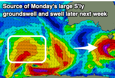
The change will be linked to a final, strong low firing up on the tail of the current frontal activity, with it forecast to generate a fetch of severe-gale to possibly storm-force SW winds while racing through our southern swell window tomorrow, clipping us Sunday.
This low will generate the largest of the swell pulses this coming period, with a strong kick in size due overnight Sunday and Monday morning to 8ft across the Surf Coast, 8ft to occasionally 10ft to the east, easing through the day.
Unfortunately a high moving in behind Sunday's change will see gusty S/SE winds into Monday, easing a little later in the day, much better Tuesday and E/NE tending N/NE with rapidly easing surf from 3ft+ on the Surf Coast, 4-5ft to the east.
Wednesday will be small along with what looks to be N'ly winds ahead of a trough and late S/SW change. There is the possiblity of some sneaky S/SE groundswell across selected spots Wednesday from the backside of the low as it moves into the Tasman Sea Monday, though only across selected spots.
Longer term, some good mid-period W/SW swell is due into the end of next week followed by more activity the following weekend as a couple of healthy frontal systems fire up to the south-west of Western Australia. Winds generally look to be out of the eastern quadrant, but we'll review this Monday. Have a great weekend!

