Large swells for the weekend and early next week with tricky winds
Victorian Surf Forecast by Craig Brokensha (issued Wednesday February 28th)
Best Days: Today beaches, Friday morning Surf Coast, Sunday morning Surf Coast, Tuesday exposed beaches, Wednesday and Thursday mornings exposed beaches
Features of the Forecast (tl;dr)
- Small background W/SW swell tomorrow with W/NW winds, shifting SW later morning and S/SW into the PM
- Moderate sized, mid-period W/SW swell building Fri, peaking in the PM
- W/NW-NW winds Fri AM, tending S/SE and then S/SW through the PM
- Large W/SW groundswell building Sat, peaking in the PM, with a similar sized, more consistent reinforcing swell Sun
- Fresh to strong SW-S/SW wind Sat (likely light W early on the Surf Coast)
- Mod-fresh W/SW-SW winds Sun, likely W/NW early Surf Coast
- Large, reinforcing S/SW groundswell Mon AM, easing with gusty S/SE winds
- Easing swell Tue with E/NE tending N/NE winds ahead of late SE sea breezes
Recap
The beaches improved through yesterday as winds shifted more offshore along with a good pulse of mid-period SW swell to 2-3ft to the west and 4ft to the east.
This morning conditions are more organised and clean across both regions with a touch less size, coming in at 2ft on the Surf Coast and 3-4ft to the east. Winds will strengthen from the N/NE into the late afternoon and evening ahead of a mid-late evening SW change.
This week and next (Feb 29 – Mar 8)
Following this evening's change, we'll see winds shift back to the W/NW tomorrow morning with small background levels of swell holding 2ft on the Surf Coast and 3-4ft to the east. Winds will shift SW later morning and then S/SW into the afternoon, so surf before then.
We then look at our stronger pulses of W/SW swell into Friday and Saturday, generated by a strong polar low that fired up to the south-west of Western Australia earlier in the week.
Friday's building mid-period W/SW energy was generated by a fetch of strong to gale-force W/NW winds at the head of the low, with a stronger pulse of groundswell Saturday being generated by gale to severe-gale W/SW winds at the tail of the low.
Friday's swell should build to 3ft+ through the day on the Surf Coast and 4-6ft to the east (smaller early), with Saturday's stronger pulse building to 4-5ft+ on the Surf Coast magnets into the afternoon, 6-8ft to the east.

Now, winds still look average, though Friday morning should remain cleaner longer with a light W/NW-NW offshore lasting until about midday before S/SE sea breezes develop, reverting back to the S/SW through the rest of the afternoon.
Fresh to strong SW tending S/SW winds are due into Saturday, with a short period of weaker, W'ly winds likely early on the Surf Coast for the keen.
Sunday now looks a touch better wind wise as well with a morning W/NW breeze due on the Surf Coast, WSW-SW elsewhere, strengthening from the SW through the day.
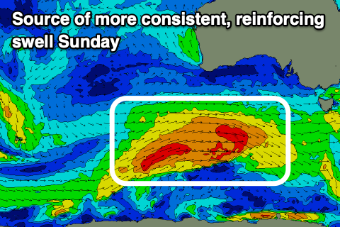
Swell wise, another large pulse of more consistent reinforcing swell is due, generated by a strong frontal system firing up on the tail of the polar low, pushing under Western Australia tomorrow (shown above left). This should maintain 4-5ft+ waves on the Surf Coast with 6-8ft sets to the east.

Behind, this one final strong low is due to fire up, south-west of us on Sunday, generating a fetch of severe-gale to storm-force SW winds late in our swell window. This should generate a large S/SW groundswell Monday morning to 6ft+ on the Surf Coast, 8ft to the east, easing through the day.
Winds will finally shift around to the S/SE on Monday, creating poor conditions, much better and improving Tuesday with E/NE-N/NE winds along with good, easing surf from 3ft+ and 4-5ft respectively west and east of Melbourne.
For the rest of the week small pulses of swell with favourable morning winds look on the cards but we'll look at this closer on Friday.

