Fun waves on the beaches for the coming days
Victorian Surf Forecast by Craig Brokensha (issued Friday January 5th)
Best Days: Exposed beaches tomorrow morning, Sunday and Monday morning
Features of the Forecast (tl;dr)
- Small, inconsistent background SW energy for today and tomorrow, easing Sun
- E/NE-NE tending gusty SE winds tomorrow to the east, variable E/SE-SE tending S/SW to the west
- Freshening N/NE winds Sun, tending NW for a period to the west during the day
- Late increase in small-mod sized mid-period SW swell Sun, peaking Mon AM with E/NE-NE tending S winds, freshening to the east, with variable morning winds to the west
- Small Tue with early W/NW tending strong SW-S/SW winds
- Small Wed with SW winds (possibly light W early)
Recap
Poor surf across all locations yesterday with a gusty onshore wind, strengthening through the afternoon to the west, while this morning winds have a touch more east in them. Selected spots to the east are offering an OK wave with inconsistent sets to 3ft to occasionally 4ft.

Still a bit of size on the beaches this AM
This weekend and next week (6 - 12)
The weekend ahead will see cleaner conditions develop across the beaches as an inland trough that's bringing wide-spread instability and rain drifts south-east across Victoria.
This will see winds shift E/NE-NE tomorrow morning on the Mornington Peninsula and Phillip Island regions with light E/SE-SE winds to the west. The afternoon will become bumpy with freshening sea breezes, lighter to the west.
Swell wise, background levels of S/SW swell should come in around 2ft+ on the Surf Coast magnets, 3ft mostly to the east with the rare 4ft'er, smaller into Sunday morning.

Conditions will be clean across the beaches again on Sunday with freshening N/NE winds, tending NW for a period on the Surf Coast into the afternoon.
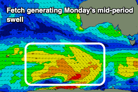
Later in the day, we may see a new pulse of mid-period SW swell that's due to peak Monday, generated by a healthy fetch of strong W/NW winds that are currently to the south-southwest of Western Australia
The swell should offer inconsistent 3ft sets on the Surf Coast magnets, 4ft to occasionally 5ft to the east but generally 2-3ft and 4ft+ respectively, easing through the afternoon.
Conditions will be clean in the morning, with winds tending E/NE-NE to the east and variable to the west, shifting S'th later morning and freshening into the afternoon as we fall under the backside of the inland trough.
We may see winds shift W/NW temporarily Tuesday morning before reverting back to the SW and strengthening further from the S/SW but with smaller surf.
Lingering SW winds are due into Wednesday but swell wise, only small levels of background energy are due.
Longer term, a better swell producer may develop through next week, with a slow moving frontal system pushing under the country early-mid week generate a moderate sized W/SW swell for Friday/Saturday but we'll have a closer look at this on Monday. Have a great weekend!


Comments
Morning offshore still a possibility for Monday sir Craig.? Or disappeared like Victoria’s surf in general
Agh, yeah gone now for the east, the change is coming in earlier. The Surf Coast looks dicey as well now :(
We're only allowed 1 day of offshores per week max during summer in vic.
Some recent wild weather in NE Vic:
https://www.abc.net.au/news/2024-01-04/north-east-victorian-wild-weather...
And some more on the way from Sunday onwards:
https://www.abc.net.au/news/2024-01-06/storms-flash-flooding-forecast-fo...
'"The amount of moisture across the state at the moment, it's incredible — it's what you would normally see in somewhere like Queensland," Mr Efron said.'
Humidity has been unprecedented down here.
Watch out for Fungal diseases on your tomatoes and your toe nails.