Another round of large windy surf, then settling into a smaller period

Victorian Surf Forecast by Ben Matson (issued Monday 18th September)
Features of the Forecast (tl;dr)
- Smaller surf Tues with good winds for the Surf Coast
- Strong building swell Wed but very windy
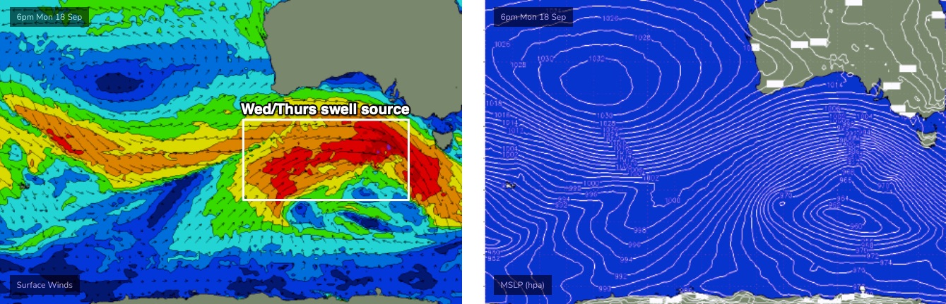
- Brief window of good winds and large surf early Thurs, though easing
- Clean Fri with easing surf
- Small and clean over the weekend with light winds, similar for much of next week
Recap
Saturday played out as expected with a small bump in swell offering slow, inconsistent 2ft+ sets across the Surf Coast, and early NW winds swinging to the west. Sunday however…. well, it was certainly quite a spectacle, with wave heights coming in much bigger than expected, solid 6ft+ sets across the Surf Coast reefs and clean with offshore winds. Size has eased a little today though we’re still seeing 4-6ft surf in Torquay, and winds have been variable from the north-east and now south so surf quality isn’t as good as Sunday. Wave heights have been even bigger west of Melbourne over the last two days. The best explanation for the over-performance of this swell is probably due to three factors - (1) the swell direction not having as much west in the regional direction as anticipated, and (2) swell size and periods coming in a little bigger than modelled (the Pt Nepean buoy recorded Tp of 20 seconds overnight Saturday), and (3) an impressive captured fetch through the southern Bight, which I failed to pick up in my analysis.
This week (Sep 19 - 22)
We’ve got another active week of surf ahead, with the Southern Ocean still quite busy with a powerful frontal conveyor belt pushing under the continent.
We’ll see slowly easing size into Tuesday with freshening NW tending W/NW winds that’ll be ideal for the Surf Coast, ahead of strong to gale force W/NW tending W/SW winds on Wednesday as the main front clips the coast. Expect fun 3-4ft surf early Tuesday, easing slowly through the day.
East of Melbourne, the open beaches will be too big and wind affected and Western Port will probably be undersized.
The first of several large swells will push through on Wednesday in sync with the westerly gales. So, aside from sheltered spots, it’s going to be a tricky day of waves unless you’re up early along the Surf Coast (winds should be W/NW for a few hours from dawn, with a brief window of smaller options).
The trailing swell will be quite westerly in direction, though I’m now a little gun-shy on downplaying size prospects, given what eventuated over the weekend (fair to say though, Wednesday’s outlook is less risky because of the blustery conditions). Let’s peg the Surf Coast as building to 5-6ft through the day, smaller earlier, with good afternoon options inside Western Port too.
Thursday will see winds easing from the SW, so most locations will be bumpy though there is a chance for an early morning W/NW breeze along the Surf Coast - though it won’t last terribly long. And, there’ll be plenty of wobble from Wednesday’s gales. A secondary W/SW tending SW swell should maintain 5-6ft sets at the Surf Coast magnets (easing later) and there’ll be workable options inside Western Port too, though keep in mind the SW wind direction will adversely affect more breaks than Wednesday W’ly flow.
Size will then continue to ease into Friday with light variable winds and lumpy leftover around the 3-4ft+ mark in Torquay, 4-6ft to the east.
This weekend (Sep 23 - 24)
We’ve got two new swells for the weekend, in addition to the existing, easing swell from Friday.
The first new groundswell will probably make landfall at the buoys on Friday, with extra long peak swell periods (22-23+ seconds, generated by the phenomenal storm below South Africa over the last few days (see article here). Suffice to say, the enormous travel distance means we won’t see much size at the Victorian coast (the swell is better aimed into Indonesia, we are merely receiving small sideband energy).
The second swell will have been generated by strong but still-distant storm activity WA of WA, near Heard Island at the moment. It’s actually sourced (mainly) from NW gales ahead of a deepening low, but we’ll see the swell energy curve back through the Great Circle path into Bass Strait.
Locally, conditions look nice and clean with light winds both days - probably tending NE at some point, if anything - and wave heights around the 2ft+ mark west of Melbourne, and 3-4ft to the east, with very long breaks between sets. Saturday morning should offer another foot or so from the easing Friday energy.
Next week (Sep 25 onwards)
General synoptic expectations for next week are that the storm track will remain closer to WA longitudes than eastern Australia, which means no major size across our region, though the distant activity looks pretty strong so there should be some good waves available most days (though it’ll be a little undersized west of Melbourne).
Such synoptic setups are also favourable for light winds, though we will be susceptible to easterlies at times, which is also a boon for the open beaches east of Melbourne.
More on that in Wednesday’s update.
Comments
W.P. after lunch on Wed. should be worth a paddle :-) .
See you out there T, with a few hundred close friends!
Beautiful conditions this morning further down the surf coast.
That wind played ball for the better part of the day. Pleasant surprise.
Cape Sorrell buoy has been cooked since last week, seems to go offline for hours at a time. Last update was 6:30pm last night